This article has been reviewed according to Science X's editorial process and policies. Editors have highlighted the following attributes while ensuring the content's credibility:
fact-checked
peer-reviewed publication
trusted source
proofread
'Shoebox' satellites help scientists understand trees and global warming

The early blooms of some of Washington D.C.'s iconic cherry blossoms this year set off a flurry of questions: Were trees communicating sensitivity to climate change?
As scientists try to understand the effect of climate on trees, advances in imaging technology are helping them see both the whole forest and every individual tree. High-resolution images taken by cubesats—small, shoebox-sized devices launched into low-Earth orbit—are helping environmental scientists make more precise measurements about trees' response to a warming climate.
With cubesat imagery, new research by Prof. Michael Alonzo, assistant professor of environmental science in American University's College of Arts and Sciences, raises questions about the role of heat in the early onset of urban forest growing seasons.
The paper is published in the journal Science of The Total Environment.
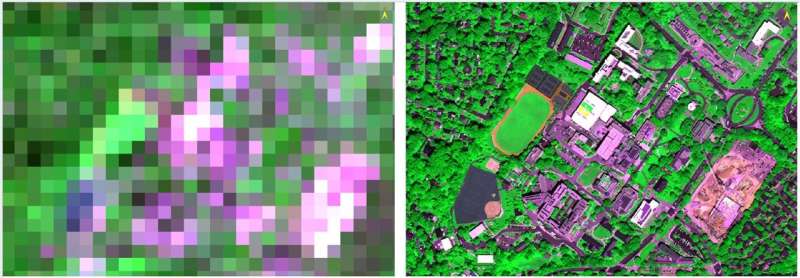
According to the findings, urban heat may not advance "green up," or seasonal vegetation leaf emergence, as much as was previously understood. This is because scientists have relied on pixelated images from moderate-resolution satellites, and the mix of plants, grasses and trees in each pixel made it look as if tree canopies in cities were greening up earlier.
"If we want to learn whether a given species or plant is changing its life cycle events due to warming, we need to do a better job zooming in on individuals and how they interact with their environment," Alonzo said.
Studying the urban heat island effect gives scientists a preview of how global warming might affect vegetation in non-urban areas. The urban heat island effect occurs when impervious surfaces trap and radiate heat and cause city temperatures to grow 2 to 3 degrees warmer than non-urban areas.
With satellite technology, scientists study large areas of trees and their growing seasons. This has led to conclusions that trees in cities green up earlier and lose leaves later compared with their those in rural and natural areas. Scientists largely attribute longer growing seasons to heat. Alonzo's work with images from cubesats is calling this into question.
"A lot of research focuses on urbanization and the urban heat island effect as the reason for longer growing seasons," Alonzo said. "Urban heat plays a role, but we may be overstating its importance."
Walk in any city, even for a short walk, and you'll see complex and varied vegetation: Cultivated trees, shrubs, and turfgrass in highly managed areas mix together closely and are interspersed with natural vegetation and impervious surface. Pixelated images do not let scientists study all these different species individually, nor does the technology provide imagery on a daily basis. Cubesat imagery allows scientists to monitor continuous changes, such as how leaves develop day after day when the growing season begins.
Alonzo and his colleagues downloaded cubesat imagery—for growing seasons from 2018 to 2020—covering more than 10,000 tree crowns on streets Washington, D.C., in a sample that included 29 species of broadleaf, leaf-shedding trees.
Piecing together hundreds of images taken nearly every day, they monitored the timing of green up in the spring and leaf loss in the fall for every tree, and analyzed how much the length of a tree's growing season could be attributed to its species, and how much to its planting location. They also considered how other site factors such as air temperature and impervious surface cover influenced these timings, using other available data.
Alonzo concludes that understanding how species composition varies between rural and urban areas is critical to improving models of how trees and other types of vegetation respond to heat. Though the study was conducted on trees in D.C., Alonzo said the findings apply to other urban and non-urban areas, and different types of trees.
While cubesats are often associated with NASA or the private space industry, Alonzo is part of a small, emerging group of scientists studying trees using its imagery. He uses many tools in his analyses of tree health, including drones, satellites, and traversing D.C. via his bicycle or car to gather air temperature readings. These tools pair well with cubesats as scientists embrace new methods for mapping and monitoring ecosystems, Alonzo said.
In the future, Alonzo will collaborate with professors in the School of International Service to use cubesat imagery to monitor changes in agricultural activity in Nigeria and forest changes in Haiti.
More information: Michael Alonzo et al, Canopy composition drives variability in urban growing season length more than the heat island effect, Science of The Total Environment (2023). DOI: 10.1016/j.scitotenv.2023.163818
Journal information: Science of the Total Environment
Provided by American University


