Craters and cracks on Mars' Terra Sirenum region
 on 5 April 2022. It was created using data from the nadir channel, the field of view aligned perpendicular to the surface of Mars, and the colour channels of the HRSC. It is a ‘true colour’ image, reflecting what would be seen by the human eye if looking at this region of Mars. The ground resolution is approximately 15 m/pixel and the image is centred at about 232°E/38°S. North is to the right. Credit: ESA/DLR/FU Berlin, CC BY-SA 3.0 IGO")
This complex region of craters and fractures in the Terra Sirenum region highlights the varied history of Mars. The image above was taken by ESA's Mars Express on 5 April 2022.
The image, taken by the High Resolution Stereo Camera (HRSC), is dominated by a large impact crater on the left (south) of the image, which measures about 70 km wide. This crater is in the Terra Sirenum region of Mars, which lies in the southern hemisphere. Another area of the same region was imaged by Mars Express in 2017.
The imprint of Martian wind is detectable within the crater—in the lower, eastern part of the crater, rough features known as yardangs are visible signatures of wind erosion. The contrasting dark-toned sand within the crater may have been transported into the flat base by wind.
Clues left by water
Nestled within the large crater is a smaller crater measuring about 20 km wide. The smaller crater and its neighbor can be seen in staggering detail in the perspective view. The structure and outline of the crater, and its smaller neighbor in the background of the perspective image, suggest that water or ice may have covered this surface when the impact occurred.
Signatures of past glaciers are visible in the smooth surface of the two neighboring craters in the perspective image. The glaciers are thought to be made from a mixture of debris and ice, which flow downhill. The sedimented debris leaves clues about the direction and movement of the ice through the small sweeping channels in the base of the craters.

Water also leaves its mark in other parts of the scene. The winding valley on the far left of the main color image measures up to 1.8 km in width. It is thought to have been a pathway for water which melted in the basin to the east.
The right (north) side of the image showcases a complex region of twisting valleys, known as dendritic valleys, whose origins are believed to be due to rain or snow early in Martian history.
Tectonic stress
The surface of the Red Planet is marked by the dynamic movements of the martian crust. Parallel to the large valley at lower left in the main color image, and about 10 km away, lies a fracture which cuts through the basin.
When the crust is pulled apart by tectonic stress, parts of the surface drop downward creating the faults. These "graben" can also be found in a region called Icaria Fossae, marked on the context map.
-
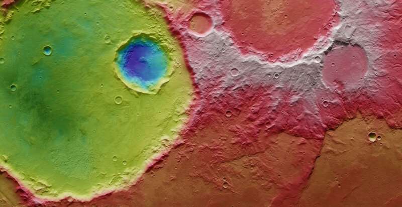
The colour-coded topographic view is based on a digital terrain model (DTM) of the region, from which the topography of the landscape can be derived. This colour-coded topographic image shows part of the cratered landscape that makes up Terra Sirenum, a large region in the southern hemisphere of Mars. It was created from data collected by ESA’s Mars Express on 5 April 2022. It is based on a digital terrain model of the region, from which the topography of the landscape can be derived. Lower parts of the surface are shown in blues and purples, while higher altitude regions show up in whites and reds, as indicated on the scale to the top right. North is to the right. The ground resolution is approximately 15 m/pixel and the image is centred at about 232°E/38°S. Credit: ESA/DLR/FU Berlin, CC BY-SA 3.0 IGO -
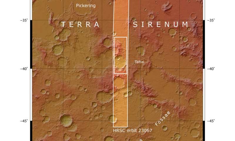
This image from ESA’s Mars Express highlights the region of Terra Sirenum in the southern hemisphere of Mars, within which craters and valleys mark the surface of the Red Planet. The region inside the bold white box contains the area imaged by Mars Express on 5 April 2022 during orbit 23067. The map indicates that the HRSC image is taken southeast of the Pickering crater, which measures around 110 km in diameter. It is an example of a crater which has been filled with lava. Credit: NASA/MGS/MOLA Science Team
Lava also makes its mark on the surface in two sections of the image of the region. While the larger crater has glacial signatures, the impact crater in the north shows signs of a layer of lava on the crater floor (labeled as the "lava filled crater" in the top image).
Small slivers, called wrinkle ridges, are marked in the lower right corner of the image. These are formed when a soft lava sheet is compressed by tectonic forces, causing a ridge where the material buckles over the lava sheet.
The array of features visible in one image shines a light on the varied physical processes and history of the Red Planet.
Provided by European Space Agency


