September 5, 2022 report
Why the Mount Nyiragongo volcano erupted with little to no warning

An international team of researchers found clues that help to explain why the Mount Nyiragongo volcano erupted with little to no warning despite the installation of seismic monitors several years prior. In their paper published in the journal Nature, the researchers describe their study of data surrounding the eruption and what they learned from it. Emily Montgomery-Brown with the U.S. Geological Survey has published a News & Views piece in the same journal issue outlining the work.
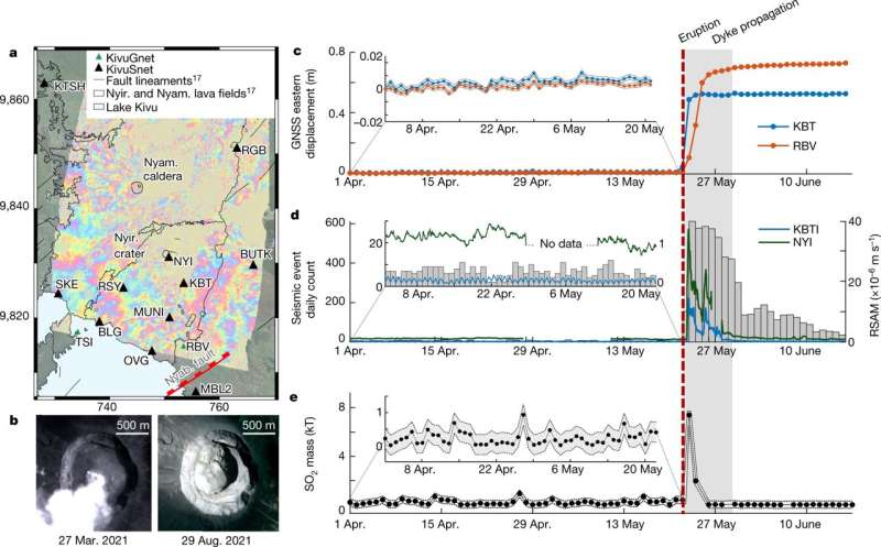
In May of last year, Mount Nyiragongo's volcano (in the Democratic Republic of the Congo) erupted, spewing lava down its side, killing hundreds of people and injuring hundreds more. The eruption and death toll were a surprise because geologists had installed seismic equipment around the volcano just six years prior. It was expected that the equipment would detect warning signs from the volcano, giving officials time to warn people in the vicinity to get out of harm's way. Instead, there was little to no warning. In this new effort, the researchers sought to find out why no warning signs had been detected.
Prior research found that there was no equipment failure—the seismic sensors had recorded signals from the volcano just fine as it was erupting over the following six hours. Thus, it seemed the volcano had erupted without any warning signals. The researchers noted that the lava lake in the volcano had risen recently, but not in an unusual way. They also noted that witnesses had described cracks appearing in the sides of the volcano with lava flowing out of them.
The seismic data just prior to the eruption showed evidence of several small quakes. The researchers also saw a small rise in infrasound waves just 10 minutes before the eruption. They suggest that stress built up in the volcanic core over time due to heat and pressure from the magma below. They also suggest that the point where the magma burst through its cap was likely very close to the surface—thus, the magma did not have to travel far before it started to cascade down the side of the mountain, leaving almost no time for the seismic probes to convey a warning.
The researchers suggest that in the future, seismic equipment will need to be custom tailored to individual volcanoes to allow for properly processing the data received and hopefully to offer advanced warning of all of the different kinds of eruptions.
More information: D. Smittarello et al, Precursor-free eruption triggered by edifice rupture at Nyiragongo volcano, Nature (2022). DOI: 10.1038/s41586-022-05047-8
Emily K. Montgomery-Brown, The search for eruption signals in volcanic noise, Nature (2022). DOI: 10.1038/d41586-022-02347-x
Journal information: Nature
© 2022 Science X Network


