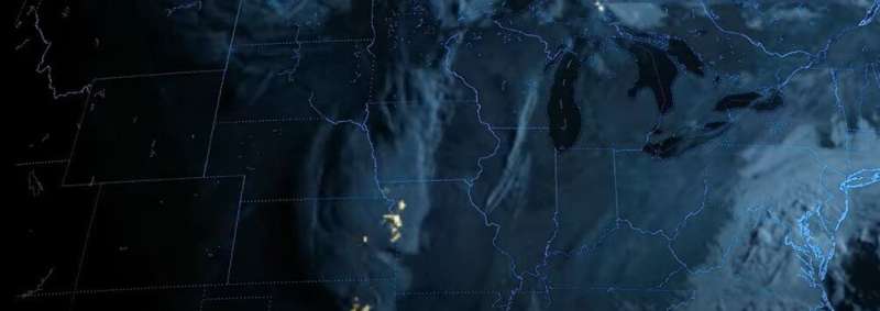
NOAA shares flashy first imagery from GOES-18 Lightning Mapper

The Geostationary Lightning Mapper (GLM) instrument, onboard NOAA's GOES-18 satellite, is now providing striking lightning observations of the Western Hemisphere. GOES-18 launched on March 1, 2022.
Recently, the GOES-18 GLM detected and monitored lightning activity in severe storms across the U.S. A derecho moved through the Northern Plains on May 12, particularly affecting eastern South Dakota and west central Minnesota. Derechos feature unusually widespread wind damage and according to NOAA's National Weather Service, the May 12 event was one of the most extreme examples on record due to the number of significant wind gusts. This derecho produced straight-line winds between 60 and 100+ miles per hour. Several tornadoes were also confirmed in the area as well as significant blowing dust. The storm uprooted trees, damaged property, caused power outages, and resulted in injuries and at least two deaths.
GLM detects and maps total lightning—in-cloud, cloud-to-cloud, and cloud-to-ground—continuously over the Americas and adjacent ocean regions. GLM offers insights beyond the presence of a lightning strike, revealing the extent of lightning flashes and the distance they travel.
Rapid increases in total lightning activity often precede severe and tornadic thunderstorms. Characterizing lightning activity in storms allows forecasters to identify intensifying storms before they produce damaging winds, hail or tornadoes. GLM data enable forecasters to detect electrically active storms, determine the extent of the lightning threat, identify strengthening and weakening storms, monitor storm evolution, and supplement radar data where coverage is poor.
Scientists and forecasters have made great advances in the five years since the first GLM data became available from GOES-16, including the ability to extract three-dimensional information from these natively two-dimensional observations. Flying along with the storms reveals just how well the GLM captures the evolution of the individual storm cells that combine to form massive storm systems. Rapidly updating GLM data gives forecasters the ability to monitor lightning flashes with pinpoint precision over much of the Western Hemisphere.
Widespread weather events pose particular challenges for the aviation industry. Increased lightning flashes as observed by GLM occur in storms with more turbulent updrafts and downdrafts, which are a significant hazard to aircraft. GLM imagery helps pilots and air traffic controllers route flights to maximize safety and minimize economic impacts.
GOES-18 is currently undergoing post-launch testing, validation and calibration of its instruments and systems to prepare it for operations. NOAA plans for GOES-18 to replace GOES-17 as GOES West in early 2023. Imagery and data from GOES-18 during the post-launch testing phase should be considered preliminary and non-operational.
Provided by NOAA Headquarters


