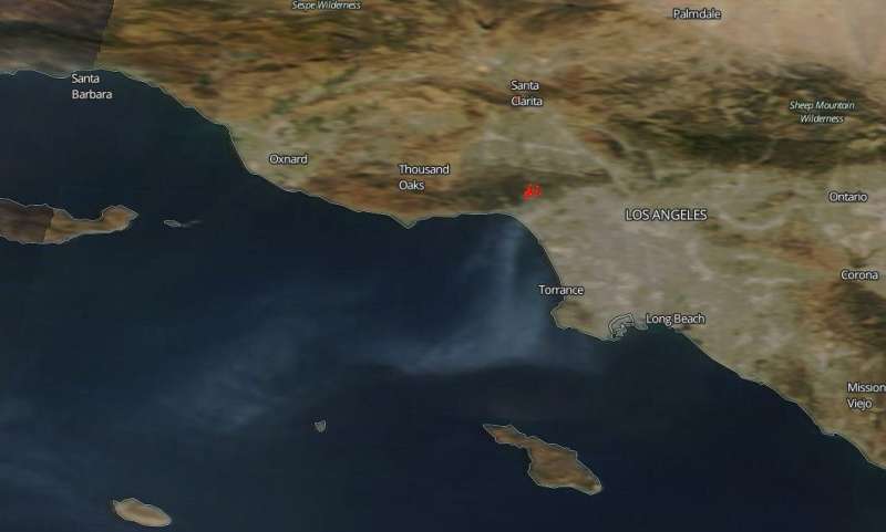
Southern California's Getty fire continues to burn

NASA's Terra satellite using the Moderate Resolution Imaging Spectroradiometer (MODIS) instrument aboard captured this image of the Getty fire shortly after it began in the early morning hours of Oct. 28, 2019. Dubbed the Getty Fire because of its proximity to the Getty Center in Los Angeles, the blaze is located in the Brentwood and Pacific Palisades area of Los Angeles County, California. Mandatory evacuations of thousands quickly followed and it is estimated that 10,000 structures are threatened and eight structures have been destroyed. The Los Angeles County Fire Department reported that the fire is 656 acres and is 5% contained. Tonight, low humidity and a resurgence of the Santa Ana winds with gusts up to 50 mph are expected to create a very dangerous scenario. The blustery weather, scheduled to continue through Thursday (according to the National Weather Service), and the steep terrain both make it difficult for firefighters to battle the blaze.
NASA's satellite instruments are often the first to detect wildfires burning in remote regions, and the locations of new fires are sent directly to land managers worldwide within hours of the satellite overpass. Together, NASA instruments detect actively burning fires, track the transport of smoke from fires, provide information for fire management, and map the extent of changes to ecosystems, based on the extent and severity of burn scars. NASA has a fleet of Earth-observing instruments, many of which contribute to our understanding of fire in the Earth system. Satellites in orbit around the poles provide observations of the entire planet several times per day, whereas satellites in a geostationary orbit provide coarse-resolution imagery of fires, smoke and clouds every five to 15 minutes.
NASA's Earth Observing System Data and Information System (EOSDIS) Worldview application provides the capability to interactively browse over 700 global, full-resolution satellite imagery layers and then download the underlying data. Many of the available imagery layers are updated within three hours of observation, essentially showing the entire Earth as it looks "right now." Actively burning fires, detected by thermal bands, are shown as red points. Image Courtesy: NASA Worldview, Earth Observing System Data and Information System (EOSDIS). Caption: Lynn Jenner with information from the Los Angeles Fire Department website.
More information: For more information visit: www.nasa.gov/mission_pages/fir … /missions/index.html
Provided by NASA's Goddard Space Flight Center


