From rain to flood

Extreme weather events such as thunderstorms, heavy rainfall and resulting floods, influence Earth and environmental systems in the long term. To study the impacts of hydrological extremes holistically—from precipitation to water entering the ground to discharge to flow into the ocean—a measurement campaign at Müglitztal/Saxony is about to start under the MOSES Helmholtz Initiative. The measurement campaign is coordinated by Karlsruhe Institute of Technology (KIT).
A single heavy rainfall event may have serious impacts on an entire river system, ranging from land erosion by floods to nutrient and pollutant transports to changes of the ecosystem. The current MOSES measurement campaign studies hydrological extreme events from the source in the atmosphere to response of biosystems.
MOSES stands for "Modular Observation Solutions for Earth Systems." Within this joint initiative, nine research centers of the Helmholtz Association set up mobile and modular observation systems to study the impacts of temporarily and spatially limited dynamic events, such as extreme precipitation and discharge events, on the long-term development of Earth and environmental systems. The current measurement campaign on hydrological extremes coordinated by KIT takes place from mid-May to mid-July 2019 at Müglitztal, Saxony. In this region, located in the Eastern Erzgebirge (Ore Mountains), certain weather conditions may result in extreme precipitations and floods, an example being the flood of 2002. Such extreme events are triggered either by depressions that, together with blockage effects by mountains, cause high precipitation, or by small-scale convective precipitation events, i.e., thunderstorms, that may be associated with floods in a limited area like a mountain valley.
Apart from the Troposphere Research Division of KIT's Institute of Meteorology and Climate Research (IMK-TRO), the Helmholtz Centre for Environmental Research (UFZ) Leipzig, Forschungszentrum Jülich (FZJ), and the Helmholtz Centre Potsdam—German Research Centre for Geosciences (GFZ) are involved in the current measurement campaign with their measurement systems.

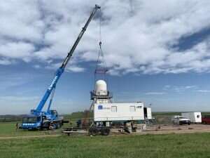
KIT will use its mobile KITcube observatory. Its supplies information on the formation and development of strong rainfall, precipitation distribution, and evaporation. Among others, a radar is applied to measure precipitation within a radius of 100 km, a microwave radiometer serves to determine the atmospheric temperature and humidity profiles, and a lidar system is used to measure the wind profile with the help of lasers. Radiosondes supply information on the state of the atmosphere up to 18 km height. A network of distrometers, i.e. systems for continuous monitoring of precipitation intensity and raindrop size, supplies additional information on processes in the observation area.
UFZ scientists will focus on soil humidity that is an important variable to control discharge of rainwater. If the soil is too humid or extremely dry, rainwater flows off the land surface and floods may develop more quickly. To optimally monitor the development of soil humidity, UFZ will install a mobile, wireless sensor network to measure soil humidity and temperature at variable depths. In contrast to classical systems, the sensor network allows precise adjustment of sensor positions and distribution as well as of scanning rates to local measurement conditions. Apart from the stationary sensor network, mobile cosmic ray rovers with specially developed neutron sensors will be applied. With them, researchers can observe large-scale variation of soil humidity in the Müglitz catchment area.
Scientists of Forschungszentrum Jülich will launch balloon probes up to 35 km height to determine, among others, how thunderstorms affect climate in the long term. Using water vapor, ozone, and cloud instruments, they study trace gas transport through thunderstorms into the upper troposphere—the bottom layer of the Earth's atmosphere—or even into the stratosphere above.
GFZ researchers will use mobile measurement units to study the influence of stored water on the development of a flood. Apart from cosmic ray sensors to measure water in the upper soil and sensors to measure close-to-surface groundwater, they will also use so-called gravimeters. These systems detect variations of the Earth's gravity due to changing underground water masses, also at larger depths.
More information:
Homepage of MOSES:
www.ufz.de/moses/ External Link
More about the KIT Climate and Environment Center:
www.klima-umwelt.kit.edu/english External Link
Additional materials:
blogs.helmholtz.de/moses/ External Link
Provided by Karlsruhe Institute of Technology


