NASA's infrared vision reveals Tropical Cyclone Haleh's power

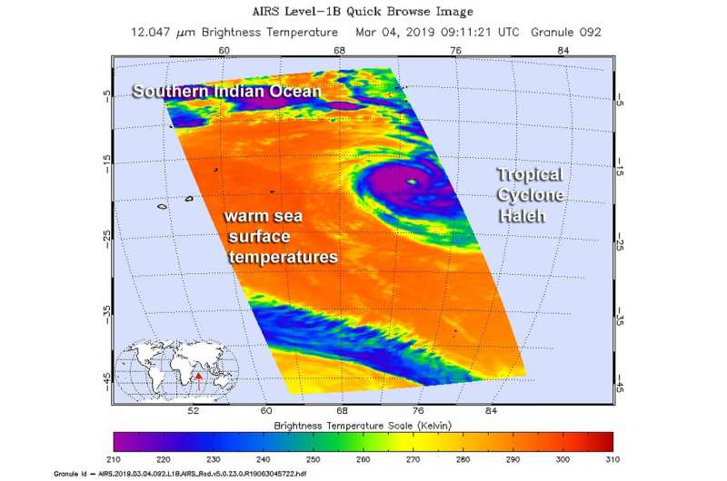
Tropical Cyclone Haleh maintained an eye as NASA's Aqua satellite passed overhead and collected temperature information on the storm and the ocean waters it was moving through.
Haleh developed as a tropical storm in the Southern Indian Ocean on March 2, about 337 nautical miles south-southeast of Diego Garcia. Haleh continued to intensify as it moved in a southerly direction and reached hurricane-force on March 3.
The Atmospheric Infrared Sounder or AIRS instrument aboard NASA's Aqua satellite passed over Tropical Storm Cyclone Haleh on March 4 at 4:11 a.m. EDT (0911 UTC) and analyzed the storm in infrared light. Infrared light provides temperature data and that's important when trying to understand how strong storms can be. The higher the cloud tops, the colder and the stronger they are.
When Aqua passed over Haleh, the AIRS instrument found coldest cloud top temperatures in thunderstorms around the eye of the storm, where temperatures were as cold as minus 63 degrees Fahrenheit (minus 53 degrees Celsius). Storms with cloud top temperatures that cold have the capability to produce heavy rainfall.
At 11 a.m. EDT (1500 UTC) on March, 5, 2019, the Joint Typhoon Warning Center or JTWC noted the center of Tropical Cyclone Haleh was located near 21.1 degrees south latitude and 71.7 degrees east longitude. That's 920 miles east of St Denis, La Reunion Island. Haleh was moving toward the southwest. Maximum sustained winds are near 109 mph (95 knots/176 kph) with higher gusts. Some weakening is forecast to continue and the storm is expected to become extra-tropical in 5 days.
Provided by NASA's Goddard Space Flight Center


