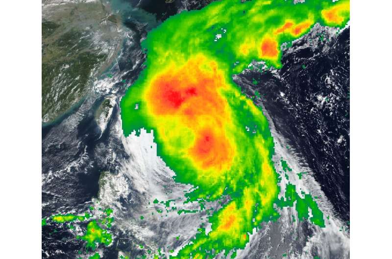
NASA puts together a composite of Tropical Storm Kong-Rey

NASA's IMERG combines data from many satellites to provide a look at rainfall occurring around the world. Those rainfall data were combined with visible imagery from NASA-NOAA's Suomi NPP satellite to create a composite or fuller picture of Kong- Rey in the Northwestern Pacific Ocean as it weakened to a tropical storm.
The Global Precipitation Measurement mission or GPM core satellite provided a look at distribution of rainfall within Kong-Rey. GPM is a joint mission between NASA and the Japan Aerospace Exploration Agency, JAXA. GPM found heaviest rain falling around the center and northwest of the center on Oct. 4, 2018.
The Visible Infrared Imaging Radiometer Suite (VIIRS) instrument aboard NASA-NOAA's Suomi NPP satellite captured a visible light image that showed the western quadrant of Kong-Rey just east of Taiwan on Oct. 4.
The Status of Kong-Rey
At 11 a.m. EDT (1500 UTC) on Oct. 4, 2018, the Joint Typhoon Warning Center downgraded Kong-Rey from a typhoon to a tropical storm as maximum sustained winds dropped to 60 knots (69 mph/111 kph). Kong-Rey was centered near 26.1 degrees north latitude and 126.5 degrees east longitude. That's approximately 88 nautical miles southwest of Kadena Air Base and has tracked north-northwestward.
Kong-Rey is forecast to turn to the north then northeast, and move into the Sea of Japan. The storm is now weakening, and will become extra-tropical over northern Japan.
About IMERG
NASA's GPM or Global Precipitation Measurement mission satellite provides information on precipitation from its orbit in space. GPM is a joint mission between NASA and the Japan Aerospace Exploration Agency or JAXA. GPM also utilizes a constellation of other satellites to provide a global analysis of precipitation that are used in the IMERG calculation.
At NASA's Goddard Space Flight Center in Greenbelt, Maryland, those data are incorporated into NASA's IMERG or Integrated Multi-satellitE Retrievals for GPM. IMERG is used to estimate precipitation from a combination of passive microwave sensors, including the Global Precipitation Measurement (GPM) mission's core satellite's GMI microwave sensor and geostationary infrared data. IMERG real-time data are generated by NASA's Precipitation Processing System every half hour and are normally available within six hours.
Provided by NASA's Goddard Space Flight Center


