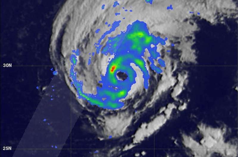
GPM satellite examines upgraded Hurricane Leslie

When Tropical Storm Leslie strengthened into a hurricane, the Global Precipitation Measurement mission or GPM core satellite passed overhead and analyzed the rates in which rain was falling throughout the stronger storm.
Although Leslie is in the Central Atlantic Ocean, it's strong enough to generate dangerous ocean swells that will continue to affect portions of the southeastern coast of the United States, Bermuda, and the Bahamas during the next few days. Swells are expected to increase near the coasts of New England and Atlantic Canada by the end of the week.
The GPM core observatory satellite passed above Hurricane Leslie on Oct. 3, 2018 at 7:33 a.m. EDT (1133 UTC). GPM is a joint mission between NASA and the Japan Aerospace Exploration Agency or JAXA.
At the time GPM passed overhead, Leslie had just been upgraded to a hurricane by the National Hurricane Center (NHC). GPM's Microwave Imager (GMI) instruments collected data that revealed light to moderate convective rainfall in Leslie's clearly evident eye wall. Very little precipitation was shown by GPM in the center of the hurricane's nearly circular eye. Algorithms developed by NASA's Precipitation Measurement Missions (PMM) science team indicated that rain was falling at over 1.8 inches (45.7 mm) per hour within storms located in the northwestern side of the Leslie's eye wall.
At NASA's Goddard Space Flight Center in Greenbelt, Md. a 3-D animation of the storm was created that showed the estimated heights of storms within hurricane Leslie at the time of the GPM satellite pass. Storm top heights are based on data observed by GPM's Dual Frequency Precipitation Radar (DPR Ku Band) blended with estimates based on geostationary satellite cloud top temperatures.
The National Hurricane Center (NHC) noted at 5 a.m. EDT (0900 UTC), the center of Hurricane Leslie was located near latitude 31.4 degrees north and longitude 57.1 degrees west. That's 455 miles (735 km) east of Bermuda.
Leslie is moving toward the north near 8 mph (13 kph), and this motion with an increase in forward speed is expected through tonight. A reduction in speed is forecast on Friday and Friday night, with Leslie accelerating toward the east or east-southeast over the weekend. Maximum sustained winds are near 80 mph (130 kph) with higher gusts. Gradual weakening is forecast during the next several days.
Provided by NASA's Goddard Space Flight Center


