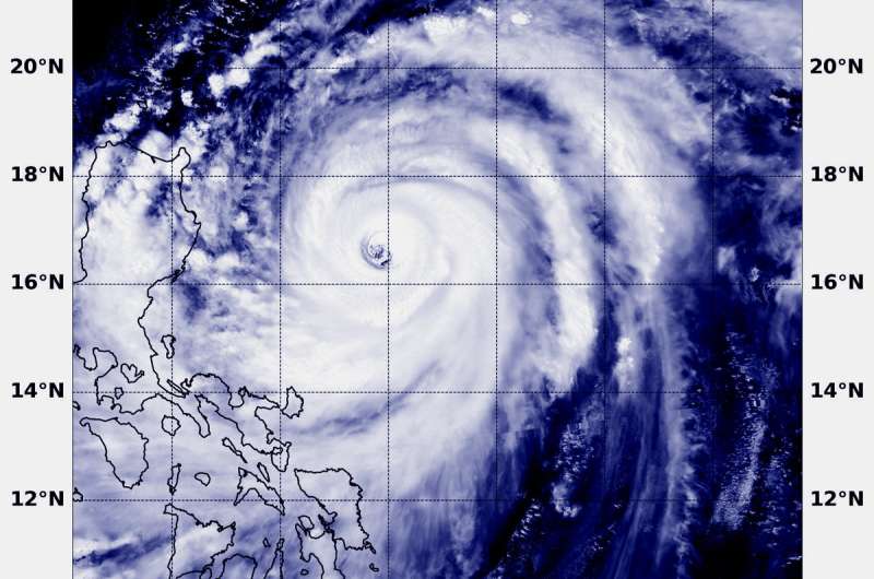
NASA sees dangerous Super Typhoon Mangkhut, eyeing the Philippines

Super Typhoon Mangkhut is a powerful tropical cyclone headed toward the northern Philippines. It is a Category 5 storm on the Saffir-Simpson hurricane wind scale. NASA-NOAA's Suomi NPP satellite provided a visible image as it passed over the Northwestern Pacific Ocean and stared the storm in its eye.
Many warnings are posted in the Philippines. They include: Public storm warning signal #3 for the Luzon provinces of Batanes, southern Isabela, Ilocos Sur, La Union, Mountain Province, Benguet, Ifugao, Nueva Vizcaya, Quirino, Northern Aurora. Public storm warning signal #2 is in effect for the Luzon provinces of Pangasinan, Tarlac, Nueva Ecija, southern Aurora, Zambales, Pampanga, Bulacan, Northern Quezon incl. Polillo Island. Public storm warning signal #1 is in effect for the Luzon provinces of Bataan, Rizal, Metro Manila, Cavite, Batangas, Laguna, Rest of Quezon, Lubang Is.,Marinduque, Camarines Norte, Camarines Sur, Catanduanes, Albay, Burias Island.
In the Philippines, Mangkhut is known locally as Ompong.
At 12:54 a.m. EDT (0454 UTC) on Sept. 14, the VIIRS instrument aboard NASA's Aqua satellite captured a visible image of Mangkhut. The image showed a symmetrical storm with a clear eye surrounded by powerful thunderstorms. At the time of the image, the western quadrant of the storm was already spreading over the eastern Philippines.
The Joint Typhoon Warning Center noted on Sept. 14 at 11 a.m. EDT (1500 UTC) Barijat's maximum sustained winds were near 167 mph (145 knots/268 kph). It was located near 17.4 degrees north latitude and 124.4 east longitude. That's approximately 245 nautical miles northeast of Manila, Philippines. Mangkhut is moving to the west-northwest.
Mangkhut is moving northwest and is forecast to pass over the north of Luzon as a category 5 equivalent typhoon. After re-emerging over water, the system is forecast to re-strengthen slightly to pass close the south coast of China towards a landfall in northern Vietnam.
Provided by NASA's Goddard Space Flight Center


