NASA satellite analyzes powerful super Typhoon Mangkhut

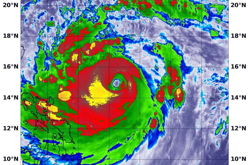
NASA's Aqua satellite provided an infrared look at powerful Super Typhoon Mangkhut early on Sept. 13 that revealed a large eye surrounded by a large area of powerful storms. Mangkhut is a Category 5 storm.
The Joint Typhoon Warning Center noted that "animated enhanced infrared satellite imagery shows deepening or strengthening convection (rising air that forms the thunderstorms that make up a tropical cyclone) with colder cloud tops." Colder cloud tops mean that the uplift of air has strengthened and pushed cloud tops higher in the troposphere. The higher and colder the cloud top, the stronger the storm and the greater potential for heavier rainfall.
At 9:35 a.m. EDT (1335 UTC) on Sept. 13, the MODIS instrument aboard NASA's Aqua satellite looked at Typhoon Mangkhut in infrared light as it was approaching the Philippines. MODIS saw that Mangkhut has a 27 nautical-mile-wide eye.
MODIS also found coldest cloud top temperatures around the eye, as cold as or colder than minus 80 degrees Fahrenheit (F)/minus 112 degrees Celsius (C). Surrounding the eye were thick rings of powerful storms with cloud tops as cold as or colder than minus 70F (minus 56.6C).
NASA research has found that cloud top temperatures as cold as or colder than the 70F/56.6C threshold have the capability to generate heavy rainfall.
At 11 a.m. EDT (1500 UTC), the center of Super Typhoon Mangkhut was located near latitude 15.2 degrees north and longitude 128.4 degrees east. That's about 465 miles east of Manila, Philippines. Super Typhoon Mangkhut was moving toward the west-northwest. Mangkhut's maximum sustained winds were near 167 mph (145 knots/268 kph) with higher gusts. Mangkhut is a Category 5 hurricane on the Saffir-Simpson hurricane wind scale.
Mangkhut is forecast to make landfall along the northeast coast of Luzon, Philippines around 5 p.m. EDT (2100 UTC) on Sept. 14. Warnings are already in effect.
Provided by NASA's Goddard Space Flight Center


