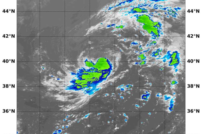
NASA sees Debby transitioned into a tropical storm

NASA's Aqua satellite passed over the Central Atlantic Ocean and looked at cloud top temperatures in Debby, revealing the storm had transitioned from subtropical to tropical.
Subtropical Storm Debby Advisory Number 1 was issued on Aug. 7 by the National Hurricane Center, Miami, Fla. Debby formed far from land areas in the Central North Atlantic Ocean.
On Aug. 8 at 1:05 a.m. EDT (0605 UTC), the Moderate Resolution Imaging Spectroradiometer or MODIS instrument aboard NASA's Aqua satellite captured an infrared image of Debby. The image showed three areas of strongest thunderstorms. They were around the center of circulation, southeastern, southwestern quadrants and in a band of thunderstorms south of the center. MODIS infrared data showed that some of those storms had cloud top temperatures as cold as minus 50 degrees Fahrenheit (minus 45.5 degrees Celsius), indicating they are high in the troposphere. Cloud tops continued to warm indicating stronger uplift in the storm, and the transition into a tropical cyclone.
The National Hurricane Center (NHC) said of the transition, "Over the past several hours, deep convection with cloud tops of minus 55 to minus 60 degrees Celsius has developed in the southeastern semicircle, with some of the convective tops covering the previously exposed low-level circulation center. In addition, outer banding features have dissipated, and an elongated upper-level anticyclone has developed over the cyclone. These convective- and synoptic-scale features indicate that Debby has made the transition from a subtropical to a tropical cyclone."
NHC reported at 5 a.m. EDT (900 UTC) on Aug. 8, the center of Tropical Storm Debby was located near latitude 40.8 degrees north and longitude 48.8 degrees west. That's 1,175 miles (1,890 km) west-northwest of the Azores Islands. Debby is moving toward the north-northeast near 9 mph (15 kph), and this general motion is forecast to continue this morning. A turn toward the northeast is forecast by this afternoon, and that motion should continue into Thursday, Aug. 9.
Maximum sustained winds have increased to near 45 mph (75 kph) with higher gusts. Little change is strength is forecast today, with slow weakening expected to begin late tonight or on Thursday.
Debby is forecast to dissipate over the far northern Atlantic by Thursday night, Aug. 9.
Provided by NASA's Goddard Space Flight Center


