NASA watches as Tropical Storm Ileana weakens from two factors

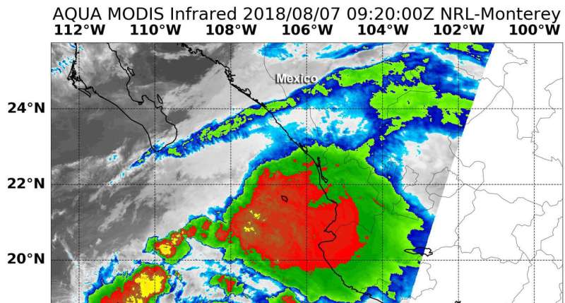
Tropical Storm Ileana continued to move north along the coast of western Mexico on Aug. 7 but cloud tops warmed as a result of interaction with land and nearby Hurricane John. Infrared data from NASA's Aqua satellite provided forecasters with temperature data that showed cloud top temperatures in Ileana were strongest around its center.
Despite moving along the coast, Ileana is keep enough distance so that the Government of Mexico has discontinued the Tropical Warning for southwestern Mexico.
On Aug. 7 at 4:20 a.m. EDT (0920 UTC) the Moderate Resolution Imaging Spectroradiometer or MODIS instrument aboard NASA's Aqua satellite analyzed Tropical Storm Ileana's cloud top temperatures in infrared light. MODIS found cloud top temperatures of strongest thunderstorms were located around the center. In that area, cloud top temperatures were as cold as or colder than minus 70 degrees (red) Fahrenheit (minus 56.6 degrees Celsius). Those cloud top temperatures had warmed since the previous day, indicating a weakening of the storm.
However, cloud top temperatures that cold indicate strong storms that have the capability to create heavy rain.
NHC noted in their discussion "Infrared and microwave satellite imagery suggest that Ileana's low-level circulation may have been disrupted by the Sierra Madre mountain range when the cyclone passed just offshore of the southwestern coast of Mexico."
At 5 a.m. EDT on Aug. 7, the National Hurricane Center cited the poorly defined center of Tropical Storm Ileana was located near latitude 19.4 N degrees north and longitude 106.9 west. Ileana is moving toward the west-northwest near 23 mph (37 kph), and this motion is expected to continue until the small tropical cyclone dissipates later today.
Maximum sustained winds are near 50 mph (85 kph) with higher gusts. Slow weakening is forecast up until Ileana dissipates later today.
Ileana is expected to produce total rain accumulations of 1 to 3 inches over coastal sections of the Mexican states of Michoacan, Colima, and Jalisco with isolated maximum amounts of 5 inches through this afternoon. These rains may cause flash flooding.
Swells generated by Ileana will be affecting portions of the coast of southwestern Mexico during the next couple of days. These swells are likely to cause life-threatening surf and rip current conditions.
NHC noted that global and regional hurricane models remain in good agreement on Ileana dissipating in less than 18 hours, due in large part from strong vertical wind created by the northwesterly outflow associated with nearby Hurricane John.
Provided by NASA's Goddard Space Flight Center


