Tropical Cyclone Gita packs heavy rain, warnings now for Tonga and Fiji

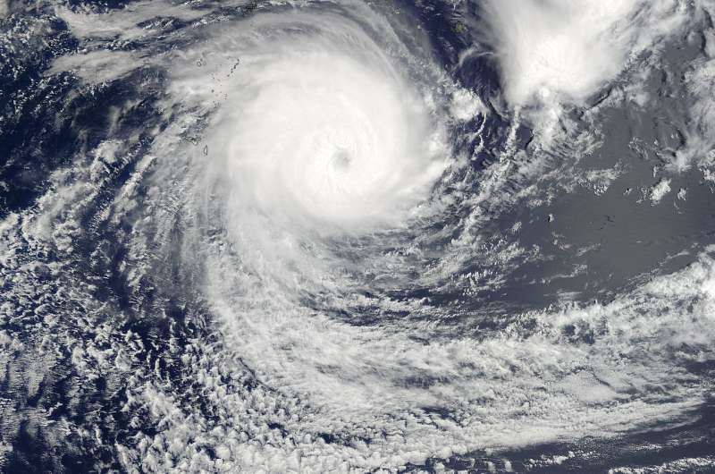
Hurricane Gita strengthened into a powerful Category 4 hurricane on Feb 12 and triggered warnings in Tonga and Fiji. NASA's Global Precipitation Measurement Mission or GPM core satellite analyzed Tropical Cyclone Gita and found heavy rainfall occurring within the system. On Feb. 12, Gita was bringing that heavy rain to Tonga and Fiji where warnings were posted. NASA's Terra satellite also provided a visible image of the storm, which had developed an eye.
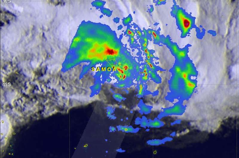
On Feb. 8 when Gita formed and was drenching Samoa, the GPM core observatory satellite passed above at 9:26 a.m. EST (1426 UTC). Data collected by GPM's Microwave Imager (GMI) and Dual-Frequency Precipitation Radar (DPR) instruments showed the area and intensity of precipitation associated with the tropical cyclone. GPM, a joint satellite mission between NASA and the Japan Aerospace Exploration Agency, found that Gita was producing heavy rainfall over a large area that included the islands.
At the time, the center of the intensifying tropical cyclone was located just to the south of the islands. Rainfall measured by GPM's radar was falling at a rate of over 64 mm (2.5 inches) per hour. The heaviest rainfall was found by GPM in bands wrapping around the eastern side of Gita Rain in one of those downpours northeast of Samoa was found falling at a rate of greater than 224 mm (8.8 inches) per hour.
At NASA's Goddard Space Flight Center in Greenbelt, Md. a 3-D view of tropical cyclone Gita's rainfall structure was created using GPM's radar data (DPR Ku Band). The 3-D image showed tallest storm tops were located in Gita's forming eye wall. Storm tops in a storm located north of Gita's center of circulation were reaching heights above 15 km (9.3 miles).
On Feb.11 at 4:35 p.m. EST (21:35 UTC) the Moderate Resolution Imaging Spectroradiometer or MODIS instrument aboard NASA's Terra satellite captured a visible image of Tropical Cyclone Gita. The image revealed powerful bands of thunderstorms circling a visible eye.
On Monday, February 12, 2018 at 9 a.m. EST (1500 UTC), A tropical cyclone Warning was in effect for Tonga and Fiji. At that time, Gita's center was located about 346 nautical miles west-southwest of Niue, near 21.5 degrees south latitude and 175.5 degrees west longitude. Gita was moving to the west-northwest at 14 mph (12 knots/22 kph). It was packing maximum sustained winds near 143.8 mph (125 knots/231.5 kph).
Warnings in effect on Feb. 12 include: A hurricane warning remains in force for Ono-I-Lau And Vatoa.

A storm warning remains in force for the rest of southern Lau group. A gale warning remains in force for Matuku, Totoya, Moala , Kadavu and nearby smaller islands, Lakeba And Nayau. A strong wind warning remains in force for the rest of Fiji.
Gita was bringing dangerous ocean swells, and the Joint Typhoon Warning Center noted that wave heights were as high as 33 feet (10.6 meters).
Gita is forecast to continue moving west through the southern outliers of the Fijian archipelago. Gita is then expected to turn southwest east of New Caledonia. For forecast updates from the Fiji Meteorological Service, visit: http://www.met.gov.fj/.
Provided by NASA's Goddard Space Flight Center


