NASA sees Tropical Storm Cindy soaking the Gulf Coast

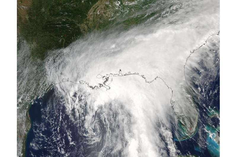
NASA's Aqua satellite captured an image of Tropical Storm Cindy after it formed and was already affecting the U.S. Gulf Coast states. Cindy continues to crawl toward land and Tropical Storm warnings are in effect for June 21.
On June 21 at 11 a.m. EDT, a Tropical Storm Warning is in effect for San Luis Pass, Texas to the mouth of the Mississippi River.
When NASA's Aqua satellite passed over the Gulf of Mexico on June 20 at 19:15 UTC (3:15 p.m. EDT), Tropical Depression 3 was already upgraded to Tropical Storm status and named Cindy. The storm was classified as a tropical storm at 2 p.m. EDT. The Moderate Resolution Imaging Spectroradiometer or MODIS instrument aboard Aqua showed Cindy's center of circulation in the central Gulf of Mexico with a large area of thunderstorms sweeping from northwest to southeast of the center, stretching from eastern Texas to Florida.
The National Hurricane Center or NHC noted on June 21 that "Heavy rainfall could produce life-threatening flash flooding across portions of the northern Gulf coast."
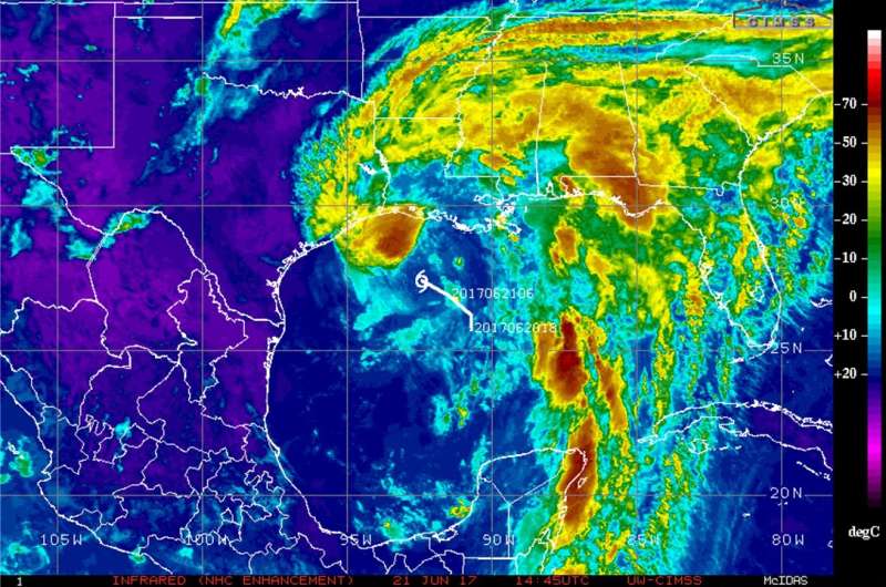
An enhanced image from NOAA's GOES-East satellite was created by the University of Wisconsin-Madison Cooperative Institute for Meteorological Satellite Studies or CIMSS. The image showed cloud top temperatures in bands of thunderstorms north and east of Tropical Storm Cindy's center on June 21 at 14:45 UTC (10:45 a.m. EDT). Some of those temperatures were as cold as minus 70 degrees Fahrenheit. Those are strong storms that were located over the Gulf of Mexico just south of Galveston, over the Florida panhandle, and over the central Gulf of Mexico. Storms with cloud top temperatures that cold have been found to generate heavy rainfall.

At 11 a.m. EDT (1500 UTC), the center of Tropical Storm Cindy was located near latitude 27.6 degrees north and longitude 92.6 degrees west. That's about 265 miles (430 km) south of Morgan City, Louisiana, and 355 miles (565 km) southeast of Galveston, Texas.
NHC said "Cindy is moving toward the northwest near 10 mph (17 kph), and this motion is expected to continue today. A turn toward the north-northwest and then toward the north is expected tonight and Thursday. On the forecast track, the center of Cindy will approach the coast of southwest Louisiana and southeast Texas late today or tonight, and move inland over southeastern Texas or southwestern Louisiana on Thursday, [June 22]."
Surface observations and reports from an Air Force Reserve Hurricane Hunter aircraft indicate that maximum sustained winds are now near 50 mph (85 kph) with higher gusts. Little change in strength is expected before landfall, with weakening expected thereafter.
Storm surge, tropical storm force winds, isolated tornadoes and heavy rain are expected. NHC noted that Cindy is expected to produce total rain accumulations of 6 to 9 inches with isolated maximum amounts of 12 inches over southeastern Louisiana, southern Mississippi, southern Alabama, and the Florida Panhandle through Thursday. Rainfall amounts of 3 to 5 inches with isolated maximum amounts of 6 inches can be expected farther west across southwest Louisiana into southeast Texas through Thursday.
For updated forecasts, visit the NHC website at: http://www.nhc.noaa.gov.
Provided by NASA's Goddard Space Flight Center


