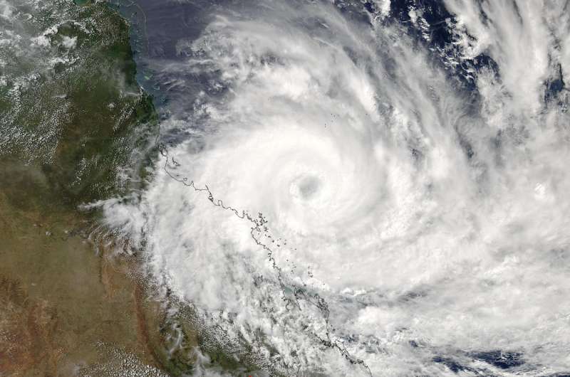
NASA sees Tropical Cyclone Debbie approaching Queensland for landfall

NASA's Aqua satellite passed over the storm early on March 27, 2017 as Tropical Cyclone Debbie had intensified into a powerful hurricane already affecting the coast of eastern Queensland, Australia.
The MODIS instrument aboard NASA's Aqua satellite captured a visible image of powerful Tropical Cyclone Debbie on March 27 at 0350 UTC (March 26 at 11:50 p.m. EST/1:50 p.m. AEST Queensland local time) as its eye approached the coast of eastern Queensland. Debbie's eye appeared cloud-filled and while still at sea, was almost parallel to Townsville.
The image showed powerful bands of thunderstorms wrapping around the low level center, and strongest storms in the western quadrant stretched along the coast from Townsville in the north, south to Mackay. The southernmost extent of the storm was near Bundaberg.
On March 27, the Australian Bureau of Meteorology or ABM warned "Severe tropical cyclone Debbie, category 4, continues moving towards the Whitsunday coast." The Australian categorization is equivalent to a Category 2 hurricane on the Saffir-Simpson Hurricane Wind Scale, which ranges from 96 to 110 mph (83 to 95 knots/154 to 177 kph).
NOAA's National Hurricane Center notes that a storm with this intensity has "extremely dangerous winds will cause extensive damage: Well-constructed frame homes could sustain major roof and siding damage. Many shallowly rooted trees will be snapped or uprooted and block numerous roads. Near-total power loss is expected with outages that could last from several days to weeks."
ABM's Warning Zone includes Lucinda to St Lawrence, including Townsville, Mackay, and the Whitsunday Islands, extending inland to Charters Towers, Mount Coolon, Moranbah, and Pentland.
At 11 a.m. EST on March 27 (or 1 a.m. AEST/Australia on March 28) Debbie's maximum sustained winds were near 175 kph (108.7 mph/ 94.5 knots). Debbie was centered near 19.8 degrees south latitude and 149.6 degrees east longitude. That's about 140 kilometers (87 miles) north-northeast of Mackay. Debbie was moving west-southwest at 8 kph (5 mph/4.3 knots).
ABM said "Severe tropical cyclone Debbie is currently a category 4 cyclone. It may intensify further as it continues to move west-southwest towards the Whitsunday coast this morning [March 28 AEST local time]. Severe tropical cyclone Debbie is forecast to make landfall between Ayr and Cape Hillsborough (north of Mackay) late this morning [March 28 AEST local time]."
Provided by NASA's Goddard Space Flight Center


