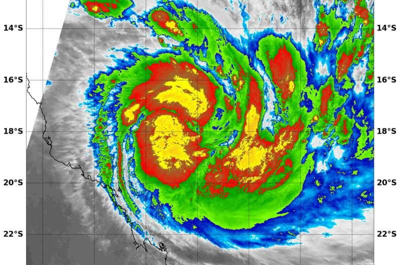
NASA sees Tropical Cyclone Debbie form and strengthen

The tropical low pressure area previously known as System 91P has developed into a tropical cyclone named Debbie in the Southern Pacific Ocean and threatens eastern Queensland, Australia. NASA's Aqua satellite provided an infrared look at the storm that revealed powerful thunderstorms quickly developed around the center. Debbie has already triggered warnings in Queensland.
The Moderate Resolution Imaging Spectroradiometer or MODIS instrument that flies aboard NASA's Aqua satellite captured infrared temperature data of the newly developed tropical storm on March 25 at 10:55 a.m. EDT (14:55 UTC). The MODIS data showed cloud top temperatures of strong thunderstorms around the center of circulation as cold as minus 80 degrees Fahrenheit (minus 62.2 Celsius). Temperatures that cold indicate strong uplift in the storm and cloud tops high into the troposphere. NASA research has shown that storms with cloud tops that cold have the ability to generate heavy rain.
The Australian Bureau of Meteorology or ABM has issued warnings and watches for eastern Queensland. The Warning zone includes: Ayr to St Lawrence including Bowen, Mackay, and the Whitsunday Islands. The Watch zone includes: remaining coastal areas from Cairns to Ayr including Innisfail and Townsville, extending inland to Charters Towers and Mount Coolon.
Details of Tropical Cyclone Debbie at 2 p.m. EST on March 25 (4:00 am AEST: on Sunday, March 26 local time). Debbie had sustained winds near 100 kph (62.4 mph/54 knots). It was located near 17.9 degrees south latitude and 151.7 degrees east longitude, about 535 km (332 miles) east-northeast of Townesville, Queensland, Australia. Debbie was moving to the west-southwest at 2 knots (2.3 mph/3.7 kph)
Tropical cyclone Debbie is expected to adopt a steady west-southwest track later Sunday morning AEST and intensify into a category 3 system by Sunday afternoon AEST. Tropical cyclone Debbie is likely to intensify further prior to making landfall between Townsville and Proserpine on Tuesday morning.
ABM said "The very destructive core of Tropical Cyclone Debbie is currently expected to cross the coast between Townsville and Proserpine on Tuesday morning, most likely as a Category 4 (Category 5 on the Saffir-Simpson Hurricane Wind Scale) tropical cyclone, with wind gusts up to 260 kph (161.6 mph) near the center,"
Provided by NASA's Goddard Space Flight Center


