NASA looks at rainfall rates in Tropical Cyclone Yvette

Tropical Cyclone 02S formed in the Indian Ocean northwest of Australia on Dec. 19 as the Global Precipitation Measurement mission or GPM core satellite passed overhead and analyzed its rainfall. On Dec. 21, Tropical Cyclone 02S was renamed "Yvette."
Australia is normally affected by 11 cyclones a year but only three formed during Australia's last summer. This year sea surface temperatures in the tropical waters around Australia are much warmer so an average tropical cyclone season is forecast by the Bureau of Meteorology (BOM).
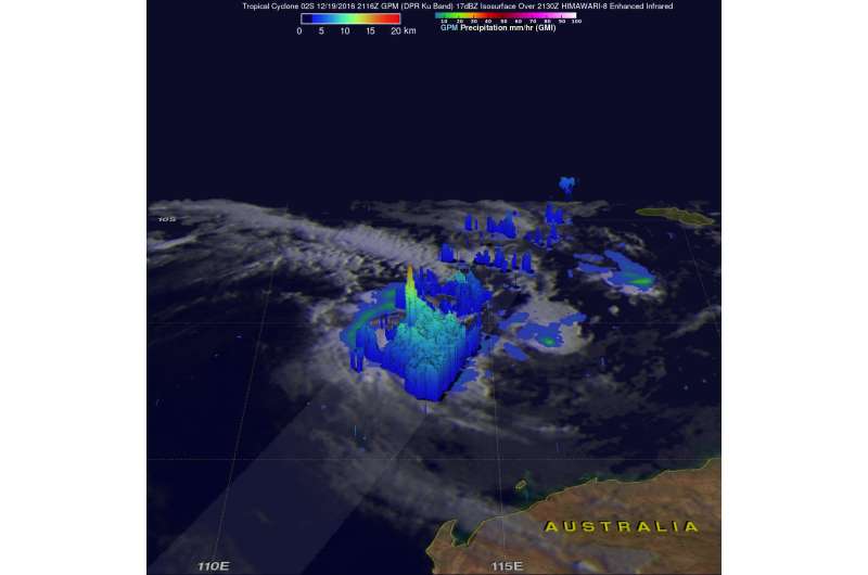
The GPM core observatory satellite flew above Tropical Cyclone 02S just a few hours after its formation on Dec. 19, 2016 at 4:16 p.m. EST (2116 UTC). Tropical cyclone 02S was relatively small but GPM found that it contained some very intense thunderstorms near the center of circulation. GPM Dual-Frequency Precipitation Radar (DPR) data showed that 02S was dropping rain at a rate of over 127 mm (5 inches) per hour in this area of intense convective showers.
GPM's radar (DPR Ku band) sliced through the tropical cyclone and revealed the 3-D structure of precipitation in storms located near the center of circulation. A few storm top heights in this area were revealed by DPR to reach altitudes above 17 km (10.5 miles).
GPM is a joint mission between NASA and the Japanese space agency JAXA.
On Dec. 21 at 4 a.m. EST (0900 UTC), Yvette had maximum sustained winds near 46 mph (40 knots/74 mph) that are expected to strengthen to 57 mph (50 knots /92 kph). before weakening in a couple of days. Yvette was located about 486 nautical miles north of Learmonth, Australia, near 14.2 degrees south latitude and 114.1 degrees east longitude. Yvette was crawling to the north at 1.5 mph (1 knot/1.8 kph) and is expected to curve to the southeast in a couple of days and head toward Australia.
The Joint Typhoon Warning Center noted that "Animated multispectral satellite imagery depicts a system with increased convection and improved consolidation (during the early morning hours of Dec. 21).
For forecast updates from Australia's Bureau of Meteorology, visit: http://www.bom.gov.au/products/IDW60281.shtml.
Landfall is expected south of Broome, Western Australia on Christmas day, Dec. 25.
Provided by NASA's Goddard Space Flight Center


