Galileo: Europe's rival to GPS

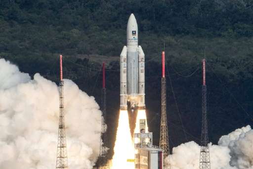
A snapshot of Europe's Galileo space-based navigation system which went online Thursday, designed to be far more precise than its US military-run rival GPS.
The basics
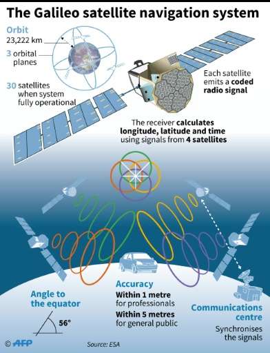
Now 18-strong, Galileo will ultimately comprise 30 satellites orbiting at an altitude of at 23,222 kilometres (14,430 miles).
Named after Italian astronomer Galileo Galilei, an early celestial navigator, it will be interoperable with GPS and Russia's GLONASS systems, but also able to run independently.
While Galileo is civil-controlled, both GPS and GLONASS are military-run, which means restrictions could be imposed for strategic reasons—as in times of war, for example.
Four more Galileo satellites are set for launch in 2017 and another four in 2018. Galileo should be 100 percent operational by 2020.
Its final four orbiters have yet to be officially ordered by the European Commission, which funds the project.
For the moment Galileo is only usable on smartphones and satnav boxes fitted with compatible microchips.
How it works
Galileo boasts the most accurate atomic clocks, four per satellite, ever used for geolocalisation.
Similar to traditional clocks relying on the tick of a pendulum, atomic clocks also count regular oscillations, in this case switches between energy states of atoms stimulated by heat or light.
Galileo's orbiters are also equipped with powerful transmitters to despatch, at the speed of light, a radiowave containing the exact time and position in Earth's orbit from which it was sent.

The time it takes for the signal to reach a receiver is used to calculate the distance from the satellite.
With several signals at once, the receiver's position can be pinpointed—four beams are required for longitude, latitude, altitude, and local time on Earth.
Accuracy
With geopositioning, a mere billionth-of-a-second clock error can throw a position off by as much as 30 centimetres (12 inches). Galileo will be accurate to one second in three million years.
Once fully deployed, Galileo aims to pinpoint a location on Earth to within a metre—compared to several metres for GPS and GLONASS.
Clients of a paying service can get even more accurate readings—down to centimetres.
Once fully operational, six to eight Galileo satellites will be visible from most positions at a given time, without counting those of GPS or GLONASS.
With so many satellites in orbit, signals will be much improved in cities where tall buildings can obstruct signals from satellites low on Earth's horizon, or in mountainous areas.
What it can do
Apart from satnav, Galileo will offer a search and rescue function as well as an encrypted "Public Regulated Service" for government services such as transport and emergency, law enforcement, border control and "peace missions".
All new cars sold in Europe by 2018 will be fitted with Galileo for navigation and emergency calls.
Its high-precision clocks will boost synchronisation of banking and financial transaction, telecommunications and energy smart-grids, making them more efficient.
It should also boost the safety of driverless cars.
© 2016 AFP


