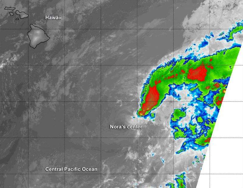
Suomi NPP satellite sees strong wind shear affecting depression

NASA-NOAA's Suomi NPP satellite passed over Tropical Depression Nora on October 14 and saw strong wind shear pushing the bulk of clouds and showers northeast of the center.
At 12:15 UTC (8:15 a.m. EDT) on Oct. 14 infrared data from the Visible Infrared Imaging Radiometer Suite or VIIRS instrument that flies aboard Suomi NPP revealed most of the depression's thunderstorms were being pushed northeast of the center from strong southwesterly vertical wind shear.
The latest University of Wisconsin- Cooperative Institute for Meteorological Satellite Studies vertical wind shear analysis showed 44 knots (50.6 mph/ 81.4 kph) of wind shear from the southwest and ships guidance showed 34 knots (39.1 mph/62.9 kph) of shear from the same direction.
VIIRS is a scanning radiometer that collects visible and infrared imagery and "radiometric" measurements. Basically it means that VIIRS data is used to measure cloud and aerosol properties, ocean color, and ocean and land surface temperatures. The Suomi NPP satellite is co-managed by both NASA and NOAA.
On October 14, 2015 at 11 a.m. EDT (5 a.m. HST/1500 UTC) Nora was a tropical depression with maximum sustained winds near 35 mph (55 kph). It was centered near 14.9 North latitude and 151.1 West longitude, about 425 miles (680 km) southeast of Hilo, Hawaii. The depression was moving toward the west near 5 mph (7 kph) and is expected to turn northwest then west by October 15.
NOAA's Central Pacific Hurricane Center (CPHC) said that swells generated by Nora will produce hazardous surf along the southeast facing shores of the big island of Hawaii through Thursday evening, October 15.
CPHC expects the depression to weaken to a post-tropical remnant low pressure area late on October 14.
Provided by NASA's Goddard Space Flight Center


