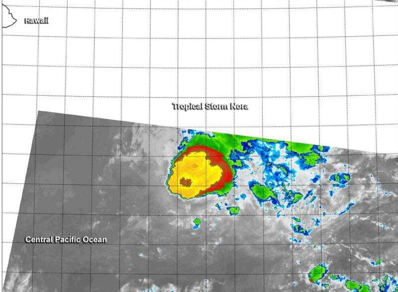
Suomi NPP gets an infrared look at Tropical Storm Nora

Tropical Storm Nora's cloud top temperatures appeared to be warming up on infrared imagery from NASA-NOAA's Suomi NPP satellite. Warming cloud top temperatures means less uplift in the air and a weaker storm. Nora is on a weakening trend according to NOAA's Central Pacific Hurricane Center as wind shear continues to batter the storm.
Nora started out on October 9 as Tropical Depression 18E in the Eastern Pacific. At 5 p.m. EDT (2100 UTC) on October 10, Tropical Depression 18E strengthened into Tropical Storm Nora. At that time, Nora was located near latitude 11.8 North, longitude 138.5 West. On Oct. 11, Tropical Storm Nora crossed the 140 degree longitude line moving from the Eastern Pacific to the Central Pacific Ocean.
Infrared data from the Visible Infrared Imaging Radiometer Suite (VIIRS) instrument aboard NASA-NOAA's Suomi NPP satellite saw Tropical Storm Nora on October 13 at 10:53 UTC (6:53 a.m. EDT).The VIIRS image showed thunderstorms wrapped around the low-level center of circulation and pushed to the east-northeast as a result of strong west-southwesterly wind shear. According to NOAA's Central Pacific Hurricane Center, the latest University of Wisconsin- Cooperative Institute for Meteorological Satellite Studies and ships wind shear analysis both show around 30 knots (34.5 mph/55.5 kph) of shear from the west-southwest.
At 5 a.m. HST/11 a.m. EDT/1500 UTC on Tuesday, October 13, 2015 the center of Tropical Storm Nora was located near latitude 14.2 north and longitude 148.6 west. That's about 575 miles (920 km) southeast of Hilo, Hawaii. Nora was moving toward the northwest near 7 mph (11 kph) and is expected to continue in that direction for the next couple days. Maximum sustained winds were near 45 mph (75 kph) and slow weakening is expected over the next couple of days.
NOAA's Central Pacific Hurricane Center expects Nora to become a tropical depression by sometime on Wednesday, October 15.
Provided by NASA's Goddard Space Flight Center


