One research vessel multiplies to hundreds

In preparation for their Arctic work GEOTRACES linked with "Float Your Boat", an education program with a unique concept. 'Float Your Boat' blends the themes of historic Arctic drift studies, modern GPS technology and hands on science, to engage local communities with work in remote science locations. Scientists currently onboard the Research Vessel Healy spent time last spring recruiting and meeting with school groups to share information about the Arctic, their upcoming science cruise and collecting small student decorated wooden boats that would become part of the project.
For over a month the science team has been anticipating the deployment of these small wooden vessels since this builds a direct connection to their families and communities back home.
The student boats are deployed in a 100% biodegradable box lowered carefully onto an iceberg along with an iridium satellite tracking buoy. The tracker is activated 'calling home' so that it can be used to track the circulation of the ice. Over time the ice is expected to melt and the box will biodegrade sending these small floating wooden boats into the high seas of the Arctic Ocean.
Once the box degrades the boats will be separated from the tracker, but each boat has been identified by the students with their school and their own name and stamped with the project contact information. If any of the boats wash up onshore there is enough information for the locator to contact 'Float Your Boat' with a date and location. Through online tracking of the iridium satellite this project provides opportunities for students to learn about Arctic change, marine circulation, marine debris transit and maritime careers.
The 'Float Your Boat' project concept comes from early Arctic science, when drifting ice floes were used to track Arctic circulation. In the International Geophysical Year (1957-58) Lamont scientist Ken Hunkins resided for two 6 month stints on Ice Station Alpha, a station built on top of the Arctic sea ice. Science teams were flown in by plane and dropped, along with their equipment, about 500 miles north of Alaska. There they studied a range of ocean parameters, including tracking their own progress as they moved along with the ice drift. The 18 months of operations tracked the ice floe movement as it shifted ~2000 miles around the Arctic in a clockwise manner until it was just north of Ellesmere Island, Canada.

Somehow the rigid presence of the Healy seems infinitely more secure than a few tents and rigs set directly on the mile long by half-mile wide section of sea ice under station Alpha.
But even earlier than the science drift experiments were the expeditions of early Arctic explorers, like Fritdjof Nansen, who froze his ship the "Fram" into the northern icepack during his voyage of 1893-1896 in hopes of drifting to the North Pole. He did not succeed, however he did learn about Arctic drift and spurred additional research on this topic, perhaps leading to these young Arctic researchers and their 'vessels'.
-
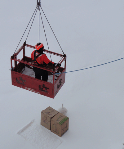
Boxes one and two are deployed on the ice with the tracker and the ship crew is pulled back up to the Healy. Credit: T. Kenna -
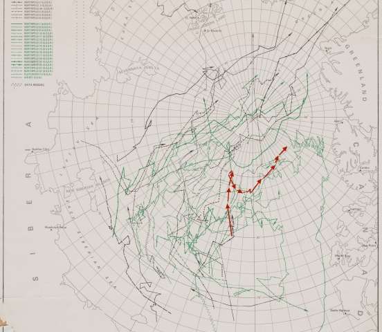
Annotated historic map of the Floating Arctic Stations, from the International Geophysical Year (1957-1958) . The red line shows Alpha Station, the US first floating ice research station, and one of the original ‘Arctic drift studies’. Credit: Photo/annotation M. Turrin; map Ken Hunkins -
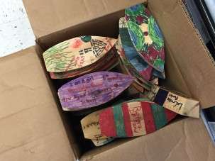
Float Your Boat ‘vessels’ were loaded into boxes and shipped to the Healy in advance of the deployment. -
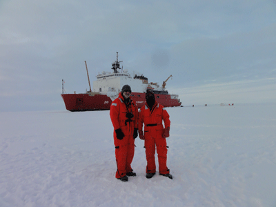
Tim Kenna is shown here on the right with Marty Fleisher on the left at the North Pole. Tim worked with several groups of local students including Pearl River High School Marine Science Club and his son’s fifth grade class at Upper Nyack Elementary School in the ‘Float Your Boat’ project for GEOTRACES.
Provided by Earth Institute, Columbia University


