NASA looks at Tropical Storm Guillermo closing in on Hawaii

NASA's Terra satellite and RapidScat provided forecasters with information about Tropical Storm Guillermo, revealing that the strongest winds were on the northern and eastern sides.
A tropical storm watch is in effect for Hawaii county, and Maui county, including the islands of Maui, Molokai, Lanai and Kahoolawe. Those areas can expect rainfall totals of 1 to 3 inches, locally up 7 inches in higher terrain. In addition, east facing shores of the Hawaiian Islands will see large surf through the rest of the week.
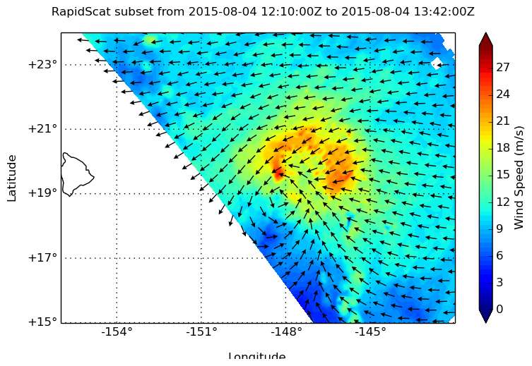
From its perch on the International Space Station, the RapidScat instrument gathered surface wind data on the Central Pacific Ocean's Tropical Storm Guillermo on August 4 at 9 a.m. EDT as it neared Hawaii. RapidScat data showed the strongest winds on the northern and eastern sides, while winds on the western side of the storm were much weaker. Strongest sustained winds were between 24 and 27 meters per second (53.6 mph/ 86.4 kph and 60.4/97.2 kph). Tropical storm force winds extend outward up to 185 miles (295 km) from the center, mainly to the north of the center.
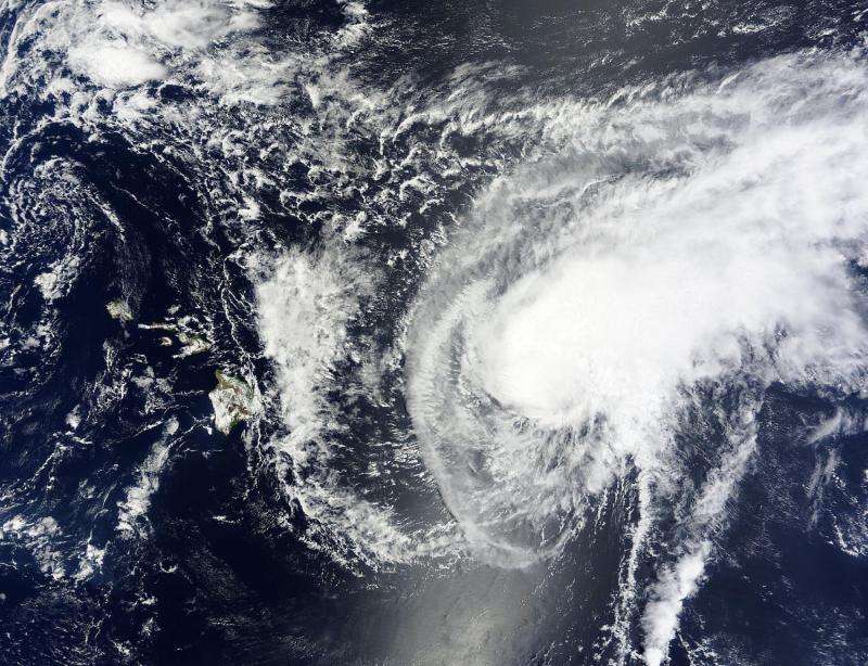
On August 4 at 20:50 UTC 4:50 p.m. EDT NASA's Terra satellite captured a visible image of Tropical Storm Guillermo. In the image thunderstorms surround the center of the circulation but area also pushed to the northeast of the center from wind shear. RapidScat data confirmed that the northeastern quadrant is where the strongest winds were occurring.
At 11 a.m. EDT (5 a.m. HST/1500 UTC) on August 5, the center of tropical storm Guillermo was located near latitude 20.5 North and longitude 151.2 West. It was about 260 miles (415 km) east-northeast of Hilo, Hawaii. Maximum sustained winds are near 60 mph (95 kph) but the National Hurricane Center expects steady weakening over the next couple of days.

Guillermo is moving toward the west-northwest near 9 mph (15 kph) and is expected to continue in that direction. The center of Guillermo is expected to pass about 160 miles north-northeast of the big island late tonight, August 5, and 90 miles north-northeast of Maui on Thursday, August 6. The estimated minimum central pressure is 999 millibars.
NOAA's Central Pacific Hurricane Center forecast calls for Guillermo to move northwest over the next several days, moving almost parallel the Hawaiian Islands. For updated forecasts, visit: http://www.prh.noaa.gov/hnl/cphc/
The storm is moving into an area of increasing vertical wind shear and is expected to weaken to a depression by August 6.
Provided by NASA's Goddard Space Flight Center


