HabCamV4 sees large numbers of young scallops off Delaware Bay

NOAA researchers and colleagues from the Woods Hole Oceanographic Institution (WHOI) have reported what appears to be a banner year for young sea scallops off the Delmarva Peninsula in mid-Atlantic waters of the U.S.
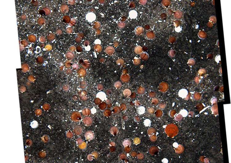
NOAA's HabCamV4, a towed imaging and sensor platform, has photographed miles of sea bottom packed with as many as 350 sea scallops in less than 1 square meter (less than three square feet). Other colorful images captured by the HabCam showed swimming scallops, sea stars and crabs—both scallop predators—and many species of fish, squid and sponges.
"The images are amazing, and we have not seen densities like this since 2003," said Deborah Hart, a mathematical biologist at the Woods Hole Laboratory of NOAA's Northeast Fisheries Science Center (NEFSC) who also leads the agency's sea scallop stock assessment effort. "One scallop per image is considered high density, so seeing hundreds in an image is really exciting, and potentially very good news for future harvests."
The findings were made during the annual federal sea scallop resource survey conducted on the 146-foot research vessel Hugh Sharp, operated by the University of Delaware. The survey used NOAA's HabCamV4, a towed platform equipped with stereo cameras and strobes, side-scan sonar, a plankton microscope, and a variety of environmental sensing instruments. It operates throughout the sea scallop fishing grounds from the Mid-Atlantic Bight to Georges Bank. The HabCamV4, developed at WHOI, is a sophisticated Habitat Camera Mapping System. WHOI scientists, Scott Gallager and Amber York are aboard the Sharp for the survey as research collaborators.
NOAA's HabCamV4 is towed behind the Sharp at around 6 knots (about 7 miles per hour) about two meters (roughly 6 feet) above the sea floor. It takes six overlapping images every second to create a continuous mosaic of the ocean floor over many miles in great detail. Computer servers on the vessel store the images and environmental data from the sensors on the HabCam, along with information from the ship's computer systems about its location, speed and other operating details. One in every 50 images is annotated manually, meaning scallops, fish and other organisms and the habitat in that image are described on a computer file, while every image is classified automatically using machine vision tools, explained Gallager.

"We're seeing many swimming scallops and other behaviors that are providing insights into how the animals live and interact in that environment," Hart said. "Baby scallops are seen attached to adults, and other scallops are swimming above the bottom, perhaps to diffuse to areas that are less dense and provide more room to grow."
"Swimming scallops—particularly young ones—are known to occur due to the presence of predators, but some of these scallops were over one meter (about three feet) off the bottom without any predators in the area. This means that there is a tremendous potential for transport in the water column once they leave the bottom," added Gallager, a biologist at WHOI and principal developer of HabCamV4.
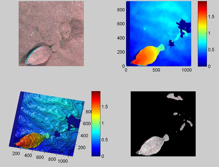
"The stereo imaging capability on HabCamV4 is allowing us to measure precisely the size of the scallops regardless of their orientation, their altitude off the bottom, and swimming attack angle. Knowing the altitude and attack angle, we can predict their swimming speed and how far they may be carried by the currents," Gallager said. "It may very well be that swimming is the main mechanism for post-settlement dispersal, and that is what controls where we see scallops downstream of such events."
The NEFSC's annual sea scallop survey is conducted in three segments or "legs," each ranging from 11 to 14 days, between May and July, beginning with the Mid-Atlantic Bight, then Southern New England and ending on Georges Bank. The Hugh Sharp departed the NEFSC's Woods Hole Laboratory for the Georges Bank leg on June 11 and returned to port June 24. HabCamV4 is used alongside an 8-foot scallop dredge, which collects physical samples of the scallops.
"Leg one in the Mid-Atlantic was all HabCam all the time," Hart said, noting that nearly four million images were taken in just two weeks. The Virginia Institute of Marine Science (VIMS) is conducting a fine-scale industry-based dredge survey of the entire Mid-Atlantic scallop resource area, in a project funded through the 2015 scallop research set-aside program. The research set-aside program, in which a portion of the annual quota is set aside to support research important to the fishery, is unique to the Northeast.
Commercial scallop vessels are being used as the platform for the VIMS work. "We have completed two of the three legs and are now on the third," said Dave Rudders of VIMS and lead scientist on the dredge survey. "Preliminary results from our dredge survey suggest a widespread recruiting year class of scallops distributed broadly throughout the survey area. The locus of the event is in the Elephant Trunk area, which is what the HabCam survey of that area is confirming visually."
Legs two and three of the NEFSC scallop survey are a combination of HabCam tows and scallop dredging, with another two million images collected on each of those legs. Using the dredge and HabCam methods in tandem increases both survey efficiency and the accuracy of estimated scallop biomass. Unlike a dredge, which only captures some of the scallops it travels over, a camera can reveal all the scallops.
The HabCam (Habitat Mapping Camera System) concept was developed jointly by scientists and engineers at WHOI with commercial fishermen and input from the NEFSC. It has been funded at different stages in its development by NOAA Fisheries, the scallop industry's Scallop Research Set-Aside Program, the Northeast Consortium, and NOAA's Integrated Ocean Observing Systems program. HabCamV4 was a collaborative effort between the NEFSC, NOAA Fisheries and the WHOI HabCam Team to develop a tool that could survey sea scallops as well as provide quantitative information about habitat and the marine ecosystem. It was first used in 2012 on the annual sea scallop survey and has also been used by the NEFSC to survey yellowtail flounder, black sea bass habitat, and potential sites for offshore wind farms in the Mid-Atlantic area.
Provided by Woods Hole Oceanographic Institution


