Scientists solve mystery of ancient American lakes

(Phys.org) —A new study by Stanford scientists solves a longstanding mystery of how ancient lakes in the western United States grew to such colossal sizes.
The research, published in the journal Geological Society of America Bulletin, found that the lakes were able to grow large – rivaling the Great Lakes – during the peak of the last Ice Age 21,000 years ago, a period known as the "Last Glacial Maximum," because evaporation rates were significantly lower than today.
"It was previously thought that the lakes grew because there was more rain and snowfall during this period of the Earth's history," said Daniel Ibarra, a graduate student in Stanford's Department of Environmental Earth System Science and the first author of the study.
More quantitative studies of past climate could help refine the computer models used by the Intergovernmental Panel on Climate Change (IPCC) to simulate Earth's atmospheric conditions under changing atmospheric conditions, said Kate Maher, assistant professor of geological and environmental sciences, who headed the project.
"The IPCC uses climate models to simulate past and future climate, so knowing that some of the models do a better job of simulating past changes gives us more confidence that we understand the physics involved," Maher said. "That can give us more confidence in the models we use to simulate future climate change."
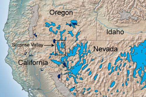
During the Last Glacial Maximum (LGM), giant lakes covered large sections of California, Nevada, Oregon and Utah, including where Salt Lake City is today. Earth scientists have long been puzzled by how these ancient lakes, now completely dry, grew so large. The prevailing theory was there was more rain and snowfall during this time period. But recent evidence from paleoecology and climate model simulations indicates that precipitation rates were actually relatively low compared to later periods.
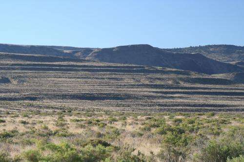
To resolve the discrepancy between computer models and the interpretation of geologic evidence, Ibarra collected more than 80 samples of tufa – a limestone created by the evaporation of mineralized water – from different locations around the edges of Lake Surprise, a moderate-sized fossil lake in Surprise Valley, California.

"The smaller lakes can tell you about the regional climate and can serve as a water gauge for the bigger lakes," Maher said.
By measuring the decay of radioactive carbon-14 and uranium in tufa samples, the team reconstructed the ancient shorelines of Lake Surprise at different times in the past. Their findings showed that at the height of the LGM, Lake Surprise had a surface area of about 390 square miles, roughly the size of San Francisco Bay.
With support from other laboratories at Stanford, Ibarra also used a mass spectrometer to precisely measure the amounts of two slightly different forms of oxygen in the tufa samples: oxygen-16 and the slightly heavier oxygen-18. Both isotopes of oxygen are present in water, but oxygen-18 water evaporates at a slower rate than oxygen-16 water. By knowing the ratio of oxygen-16 to oxygen-18 in the tufa samples, the scientists were able to calculate Lake Surprise's water balance through time.
Cooler temperatures
Their analyses revealed that 21,000 years ago, the evaporation rate at Lake Surprise was nearly 40 percent lower than today, with precipitation rates similar to the modern era. These results are consistent with previously run climate simulations that show Earth's climate was cooler during the LGM.
The cooler global temperatures would have reduced evaporation rates, allowing the lakes to gradually grow over time through inflows from streams and rivers.
"Lake Surprise is located in a closed basin. All streams flow into the lake, but there is no outflow. The only way for water to escape is through evaporation," Ibarra said.
The team's dating and isotope measurements also show that precipitation rates in the region increased for a brief period after the LGM. The tufa measurements indicated that Lake Surprise reached its largest size – around 530 square miles – 15,000 years ago.
Thus, the enormous lakes that once dotted the western United States initially grew large during the peak of the LGM due to reduced evaporation, but didn't reach their maximum sizes until several thousand years later, when rain and snowfall increased.
Knowledge about the past precipitation patterns of the region could be used to test the accuracy of the differing climate models scientists currently use to simulate global climate conditions.
"We can actually rank the models now," Ibarra said. "Our findings have implications for evaluating the models, and deciding which models successfully reproduced the past precipitation patterns we observe."
More information: "Rise and fall of late Pleistocene pluvial lakes in response to reduced evaporation and precipitation: Evidence from Lake Surprise, California," Geological Society of America Bulletin, B31014.1, first published on June 2, 2014, DOI: 10.1130/B31014.1
Provided by Stanford University


