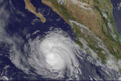
NASA sees Hurricane Cristina making a reverse in strength

Hurricane Cristina intensified rapidly on June 12 and infrared satellite data showed cloud top temperatures became extremely cold as thunderstorms towered to the top of the troposphere. One day later, Cristina was weakening quickly and infrared data showed cloud top temperatures were warming as the cloud tops dropped.
Infrared data basically reads a cloud top's temperature. When NASA's Aqua satellite passed over Hurricane Cristina early on June 12, cloud top temperatures exceeded -80C (-112F). Today, June 13, infrared data showed cloud top temperatures had warmed to near -53C (-63F) over a large area of the storm as cloud heights dropped. Cloud heights dropped because the convection had weakened.
Basically, convection occurs when a parcel of air near the Earth's surface is heated, it rises (making it lighter than the surrounding air). As convection continues the air pressure begins to fall, and the parcel of air expands. When that happens, the air consumes heat energy and temperature in the parcel falls. When the parcel of air cools enough and reaches the dew point, clouds form (condensation occurs). If the air is unstable, that convection will continue at much higher levels in the atmosphere and it can create towering thunderstorms.
The National Hurricane Center discussion on June 13 at 5 a.m. EDT noted that Cristina had weakened almost as fast as it intensified the day before. Microwave imagery suggested that the eyewall is about 50 percent open, and only occasional hints of an eye can be seen on conventional satellite data.
On June 13 at 11 a.m. EDT (1500 UTC) Cristina's center was located near latitude 18.0 north and longitude 109.6 west about 105 miles (170 km) east-southeast of Socorro Island, Mexico. Cristina was moving toward the northwest near 8 mph (13 kph) and is expected to continue in that direction over the next day before turning west-northwestward later in the weekend (June 14 and 15). Cristina's maximum sustained winds have decreased to near 100 mph (155 kph). According to forecaster Berg at the NHC, Cristina is expected to become a tropical storm on Saturday, June 14.
In a visible image of Hurricane Cristina taken from NOAA's GOES-West satellite at 11 a.m. EDT on June 13, the eye was no longer visible.
Cristina is now in a weakening trend. The NHC noted that cooling sea surface temperatures (cooler than 26C/80F) in addition to increasing shear and dry air aloft will continue to weaken Cristina to a remnant low pressure area in three or four days.
Provided by NASA's Goddard Space Flight Center


