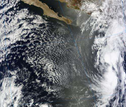
NASA sees system 90E moving toward southwestern Mexico

A tropical low pressure area known as System 90E is located a couple of hundred miles southwest of Zihuatenejo, Mexico today and was seen by NASA's Terra satellite on its way to a landfall.
The Moderate Resolution Imaging Spectroradiometer (MODIS) instrument aboard NASA's Terra satellite captured a visible image of System 90E on May 7 at 18:50 UTC/ 2:50 p.m. EDT as it headed to a landfall in southwestern Mexico. The low appeared disorganized as it approached the southwestern coast of Mexico near the states of Michoacan and Guerrero.
According to NOAA's National Hurricane Center, System 90E "is producing a large area of showers and thunderstorms that will continue to spread onshore over portions of southwestern Mexico today." NOAA said that locally heavy rainfall and gusty winds will continue primarily over portions of the Mexican states of Michoacan and Guerrero today, May 8. These rains could produce life-threatening flash floods and mud slides.
At 15:54 UTC (11:54 a.m. EDT) conditions in Uruapan, a city in the state of Michoacan, were overcast with winds from the north-northeast at 9 mph (8 knots). The air temperature was 64 F (18C). Farther south in Acapulco, located in the Mexican state of Guerrero, cumulonimbus clouds and towering cumulus clouds were reported at 15:42 UTC (11:42 a.m. EDT). Rain and light rain were reported in the two hours previous, according to observations listed on NOAA's National Weather Service Telecommunications Operations Center website. The winds were from the north-northeast at 13 mph (11 knots) and the air temperature was 80F (27C).
The low pressure area became more disorganized today because of stronger upper-level winds. The National Hurricane Center gives this low a 20 percent chance of becoming a tropical cyclone during the next 48 hours and even over the next five days.
Provided by NASA's Goddard Space Flight Center


