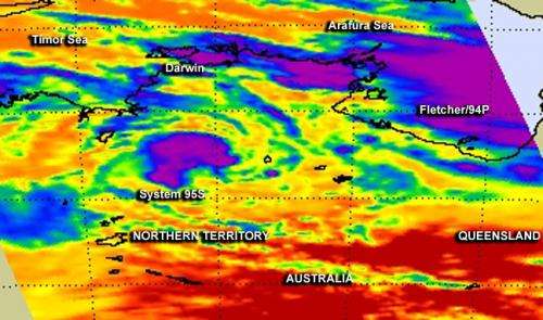
One NASA image, two Australian tropical lows: Fletcher and 95S

NASA's Aqua satellite captured two low pressure areas from different ocean basins in one infrared image. Aqua saw System 94P or Fletcher in the Gulf of Carpentaria and western Queensland and low pressure System 95S in the Northern Territory.
When NASA's Aqua satellite passed over central Australia on February 5 at 04:47 UTC, the Atmospheric Infrared Sounder or AIRS instrument gathered valuable infrared data on both low pressure areas. System 95S, which developed in the Southern Indian Ocean and moved inland south of Darwin, Northern Territory, Australia continued to maintain circulation and strong thunderstorms around its center despite being over land.
System 95S was located near 16.3 south and 132.4 east, about 245 nautical miles/281.9 miles/453.7 km south-southeast of Darwin, Australia. It appeared in AIRS data as an almost rounded area of strong storms with cloud top temperatures near -63F/-52C, which suggests heavy rainfall potential. The Joint Typhoon Warning Center or JTWC gives System 95S a low chance for development because its center remains over land.
Meanwhile, Fletcher, which developed in the Southern Pacific Ocean basin remains in the Gulf of Carpentaria and is a much larger low pressure area that covers most of the Gulf. At 0600 UTC/1 a.m. EST today, February 5, Fletcher was centered near 17.1 south latitude and 141.0 east longitude, or just 90 nautical miles/103.6 miles/166.7 km east-southeast of Mornington Island, Australia. Fletcher's convection has become more disorganized today as it continues to be battered by moderate vertical wind shear of up to 20 knots/23 mph/37 kph.
According to the JTWC, a composite radar loop at a weather station located on Mornington Island showed that the low was straddling the southeastern shore of the Gulf of Carpentaria. JTWC noted that Fletcher has a medium chance of reaching tropical depression status over the next day or two, while System 95S has a low chance.
Provided by NASA's Goddard Space Flight Center


