Gravity variations much bigger than previously thought

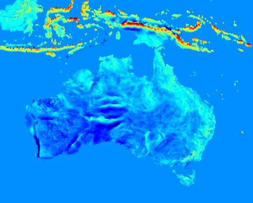
A joint Australian-German research team led by Curtin University's Dr Christian Hirt has created the highest-resolution maps of Earth's gravity field to date—showing gravitational variations up to 40 percent larger than previously assumed.
Using detailed topographic information obtained from the US Space Shuttle, a specialist team including Associate Professor Michael Kuhn, Dr Sten Claessens and Moritz Rexer from Curtin's Western Australian Centre for Geodesy and Professor Roland Pail and Thomas Fecher from Technical University Munich improved the resolution of previous global gravity field maps by a factor of 40.
"This is a world-first effort to portray the gravity field for all countries of our planet with unseen detail", Dr Hirt said.
"Our research team calculated free-fall gravity at three billion points—that's one every 200 metres—to create these highest-resolution gravity maps. They show the subtle changes in gravity over most land areas of Earth."
The new gravity maps revealed the variations of free-fall gravity over Earth were much bigger than previously thought.
The Earth's gravitational pull is smallest on the top of the Huascaran mountain in the South American Andes, and largest near the North Pole.
"Only a few years ago, this research would not have been possible," Dr Hirt said.
"The creation of the maps would have required about 80 years of office PC computation time but advanced supercomputing provided by the Western Australian iVEC facility helped us to complete the maps within a few months."
High-resolution gravity maps are required in civil engineering, for instance, for building of canals, bridges and tunnels. The mining industry could also benefit.
"The maps can be used by surveyors and other spatial science professionals to precisely measure topographic heights with satellite systems such as the Global Positioning System (GPS)," Dr Hirt said.
The findings of the research team from Curtin and Technical University Munich have recently appeared in the journal Geophysical Research Letters.
More information: Map extracts with continental coverage are available via geodesy.curtin.edu.au/research … /GGMplus/gallery.cfm
Journal information: Geophysical Research Letters
Provided by Curtin University


