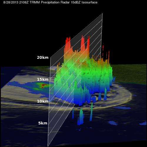
TRMM satellite sees heavy rain over Taiwan from Tropical Storm Kong-Rey

NASA's Tropical Rainfall Measuring Mission or TRMM satellite flew directly above western Taiwan on August 28, 2013 at 2108 UTC when Tropical Storm Kong-Rey was dropping enormous amounts of rain. Kong-Rey is expected to affect Japan over the next several days while moving parallel to its western coastline.
Flooding from torrential rainfall with totals of over 500 mm (~19.7 inches) have been reported in western Taiwan. A rainfall analysis from TRMM's Microwave Imager (TMI) and Precipitation Radar (PR) instruments revealed that precipitation was falling was at a rate of over 205mm/8 inches per hour in intense bands of rain over southwestern Taiwan.
TRMM data was used to create a 3-D image looking from the east, showed the extremely high storms located on the western side of Taiwan. TRMM showed that the tops of those powerful thunderstorms were often reaching heights above 16.5 km (~10.3 miles).
On Aug. 30 at 1500 UTC/11 a.m. EDT, Kong-Rey had weakened to a tropical depression with maximum sustained winds near 30 knots/34.5 mph/55.5 kph. It had passed Taiwan and was centered near 31.7 north and 126.6 east, about 251 nautical miles/288 miles/465 km west-southwest of Sasebo, Japan. Kong-Rey was moving northeastward at 13 knots/15 mph/20.9 kph.
Tropical Depression Kong-Rey is now predicted to move to the north then northeast and remain just off the western coast of Japan until it makes a brief landfall near Misawa in the north on Sept. 1. Resident along western Japan can expect showers, gusty winds and rough surf over the next several days.
Provided by NASA's Goddard Space Flight Center


