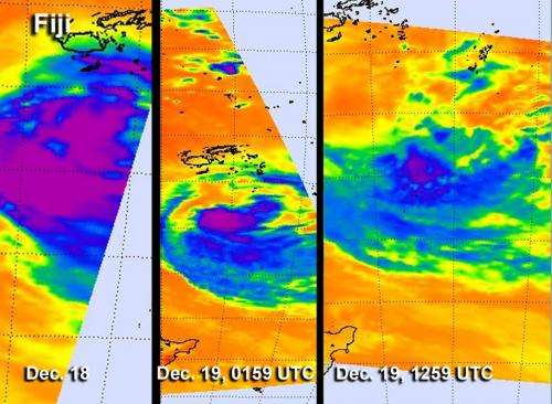
Time series of infrared NASA images show Cyclone Evan's decline

Cyclone Evan is now far south of Fiji and wind shear and cooler sea surface temperatures have been taking their toll on the storm and weakening it. Infrared data from NASA's Aqua satellite has shown a quick decline in the storm's structure over one day.
A time series of infrared images from the Atmospheric Infrared Sounder (AIRS) instrument that flies aboard NASA's Aqua satellite showed changes in intense thunderstorms within Cyclone Evan between Dec. 18 and Dec. 19. Over a time period of 36 hours, Evan weakened from Cyclone strength to Tropical Storm strength. In an AIRS image captured on Dec. 18 there were two large areas of strong thunderstorms with very cold cloud top temperatures colder than -63 Fahrenheit (-52 Celsius).
By Dec. 19 at 0159 UTC (Dec. 18 at 8:59 p.m. EST/U.S.) the area of strong thunderstorms had become smaller, and the storm appeared less organized. In the AIRS infrared image from Dec. 19 at 1259 UTC (7:59 a.m. EST), the area of strongest thunderstorms had been reduced further and cloud top temperatures throughout the storm were warming, indicating cloud heights were falling because of less evaporation. Evan had moved over sea surface temperatures below the 80 degree Fahrenheit (26.6 degree Celsius) threshold, so evaporation and thunderstorm development had waned.
Wind shear had increased as well, pushing the bulk of the thunderstorm activity about 65 nautical miles (74.8 miles/120.4 km) to the southeast, according to the Joint Typhoon Warning Center. Northwesterly wind shear was very strong, blowing between 40 and 50 knots (46 and 57.5 mph/74 and 92.6 kph). Animated multi-spectral satellite imagery also showed the low-level circulation center remains fully exposed.
On Dec. 19 at 0900 UTC (4 a.m. EST/U.S.), Evan was a tropical storm with maximum sustained winds near 45 knots (51.7 mph/83.3 kph). It was located about 335 nautical miles (385.5 miles/620.4 km) south of Nadi, Fiji, near 23.7 south latitude and 178.3 east longitude. Evan was moving to the south-southeast at 7 knots (8 mph/13 kph).
Forecasters at the Joint Typhoon Warning Center noted that because of the strong wind shear and cooler sea surface temperatures, Evan may dissipate sometime on Dec. 20.
Provided by NASA's Goddard Space Flight Center


