SPoRT captures scope of Hurricane Sandy outages

(Phys.org)—NASA's Short-term Prediction Research and Transition (SPoRT) Center has been applying enhanced, multispectral image analysis techniques to NASA satellite data to support the monitoring of SuperStorm Sandy's impacts, and assisting in ongoing disaster assessment and relief efforts.
The SPoRT Center uses Earth Observing System measurements and other satellite data to generate products useful in the analysis of weather events. SPoRT provides these products and data sets to partners including disaster response agencies.

In a recent application, data from the Visible Infrared Imager Radiometer Suite (VIIRS) low-light sensor, called the day-night-band, or DNB, on the Suomi National Polar-orbiting Partnership satellite has been used to create an experimental "VIIRS Blackout RGB Composite" product in order to help the Federal Emergency Management Agency, the U.S. Army's Joint Force Land Component Command Coordination Element and the U.S. Army Corp of Engineers to use space-based assets to help monitor regions without power as part of their disaster response activities.
"This imagery has allowed emergency response teams to expedite their response to hurricane-ravaged areas," said Dr. Gary Jedlovec, SPoRT project lead at NASA's Marshall Space Flight Center in Huntsville, Ala. "Seeing the impact of the blackout from space-based assets gives relief organizations a new and very effective view of the scope of impacted regions."
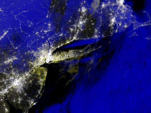
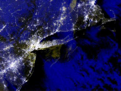
The VIIRS DNB has the ability to detect light emitted from cities and small towns in the absence of clouds. In the Google Earth display below, the day-night-band imagery captured Aug. 31, before the storm, indicates nominal nighttime lighting for the region. It was combined with similar imagery taken Nov. 1. By assigning the "before" image to the red and green colors and "after" image to blue, using an image compositing tool, the resulting combined image depicts bright white lights where town and city lights appear in all images—before and after the storm—and yellow areas in the "after" image where town and city lights are missing.
This compositing effect occurs because lights present in both the before and after image are coded white by the tool, whereas it assigns a yellow color to regions where lights appeared only in the "before" image. This experimental product highlights in yellow many of the coastal areas where power outages are likely or confirmed. Application of the technique to data captured Nov. 3 produces the second image below.
SPoRT receives real-time VIIRS data from the University of Wisconsin through a collaborative partnership under the NOAA GOES-R and JPSS programs. The processing of the VIIRS data is performed by SPoRT at MSFC.
Provided by NASA


