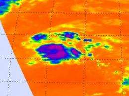
NASA view of Atlantic's Tropical Depression 19 shows backwards 'C' of strong storms

Infrared imagery from the AIRS instrument on NASA's Aqua satellite revealed that the strongest thunderstorms within the Atlantic Ocean's Tropical Depression 19 seem to form a backwards letter "C" stretching from northeast to southeast around the storm's center. That "C" is a band of thunderstorms around the eastern side of the storm.
Infrared satellite imagery taken on Oct. 22 at 12:23 p.m. EDT, from the Atmospheric Infrared Sounder (AIRS) instrument showed that the strongest thunderstorms in Tropical Depression 19 stretched from the northeast to the southeast of the center of the depression's circulation. Those thunderstorms are reaching high into the troposphere where cloud top temperatures are as cold (purple) as -63F. The AIRS image was created at NASA's Jet Propulsion Laboratory, Pasadena, Calif.
On Oct. 23, infrared satellite imagery revealed the same story about Tropical Depression 19's (TD 19) structure. The National Hurricane Center noted "The structure of the depression consists of a small but persistent cluster of deep convection regenerating near the center of circulation and an outer band farther to the north and northeast."
On Oct 23 at 11 a.m. EDT, TD19's maximum sustained winds were near 35 mph (55 kph). Some strengthening is possible over the next couple of days, and the depression could become a tropical storm. The center was located near latitude 25.7 north and longitude 51.0 west, about 915 miles (1,470 km) northeast of the Leeward Islands. TD19 is moving to the north-northeast near 15 mph (24 kph) and is expected to move northeastward to east-northeastward on Oct. 24. TD19 formed in the central Atlantic yesterday, Oct. 22. If TD19 gets named, it would be dubbed "Tony."
Provided by NASA's Goddard Space Flight Center


