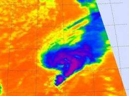
NASA sees warming cloud tops indicating Tropical Storm Tony weakening

In a tropical cyclone, strong uplift of air pushes the tops of thunderstorms high into the troposphere. When that strength wanes, the cloud tops drop and become less cold. That's because the higher you go in the troposphere, the colder it gets. NASA satellite infrared data has revealed that Tropical Storm Tony's cloud top temperatures are warming and the storm is weakening.
The Atmospheric Infrared Sounder (AIRS) instrument aboard NASA's Aqua satellite captured infrared imagery of Tropical Storm Tony on Oct. 24 at 12:17 p.m. EDT that showed the strongest thunderstorms east of the center of circulation, but cloud top temperatures are warming. Those thunderstorms are reaching high into the troposphere where cloud top temperatures are as cold as -63 Fahrenheit (-52 Celsius). The cloud pattern in Tony is also becoming less organized.
On Oct. 25, 2012 at 5 a.m. EDT Tropical Storm Tony had maximum sustained winds near 45 mph (75 kph). Tony was moving to the east-northeast near 23 mph (37 kph) and this general motion is expected to continue during the next couple of days. Tony's center is far from land, about 835 miles (1,345 km) southwest of the Azores Islands near 30.4 North latitude and 38.4 West longitude. Tropical storm force winds extend outward up to 105 miles (165 km) from the center.
According to the National Hurricane Center discussion of Tony, "the southwesterly winds have not substantially separated the surface circulation from the convective canopy, although a combination of the shear and cooler waters has weakened the deep convection."
The National Hurricane Center expects Tony to start losing tropical characteristics today and dissipate over the weekend of Oct. 27 and 28.
Provided by NASA's Goddard Space Flight Center


