NASA's Global Hawk and satellites see tropical storm Nadine turning around

Tropical Storm Nadine is turning around in two ways. When NASA's Global Hawk flew over the storm it learned that the storm was not transitioning into an extra-tropical storm. Now, NASA satellites see that Nadine is physically turning its direction, and heading back to the west-northwest and away from land.
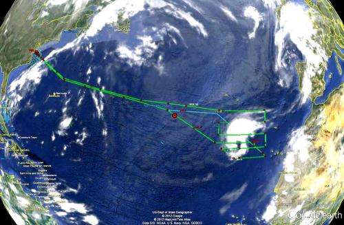
The fifth science flight of NASA's Global Hawk concluded when the aircraft landed at NASA's Wallops Flight Facility, Wallops Island, Va. on Sunday, Sept. 23 after flying over Tropical Storm Nadine in the Eastern Atlantic Ocean. The Hurricane and Severe Storms Sentinel (HS3) mission scientists changed the flight path during the Global Hawk flight to be able to overfly Nadine's center.
"Measurements from dropsondes found wind speeds greater than 60 knots at lower levels above the surface during that adjusted flight leg," said Scott Braun, HS3 Mission Principal Investigator from NASA's Goddard Space Flight Center, Greenbelt, Md. "Despite the large distance of Nadine from the U. S. East Coast, the Global Hawk was able to spend about 11 hours over the storm."
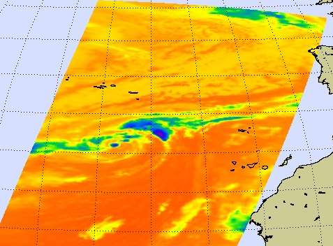
NASA's Aqua satellite passed over the eastern Atlantic Ocean on Sept. 24 at 03:23 UTC, and the Atmospheric Infrared Sounder (AIRS) instrument captured an infrared image of Tropical Storm Nadine's cloud top temperatures. The infrared data indicated the strongest thunderstorms and heaviest rainfall were to the northeast of the center of circulation. Those cloud top temperatures exceeded -63 Fahrenheit (-52 Celsius). Wind shear from the southwest has pushed the bulk of clouds and showers to the northeast.

On Friday, Sept. 24 at 11 a.m. EDT, Tropical Storm Nadine's maximum sustained winds are near 50 mph (85 kmh). Nadine was located about 440 miles (705 km) south of the Azores, near latitude 31.7 north and longitude 27.8 west. Nadine is moving west-northwest near 7 mph (11 kmh) and a gradual turn to the west and southwest is expected later.
The Hurricane and Severe Storm Sentinel (HS3) is a five-year mission specifically targeted to investigate the processes that underlie hurricane formation and intensity change in the Atlantic Ocean basin. HS3 is motivated by hypotheses related to the relative roles of the large-scale environment and storm-scale internal processes.
Provided by NASA's Goddard Space Flight Center


