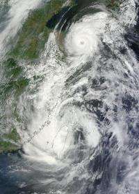
NASA satellites see Tropical Storm Saola and Typhoon Damrey arm-in-arm near China

Tropical Storm Saola and Typhoon Damrey appear on NASA satellite imagery to be arm-in-arm as they enter China on August 2.
NASA's Terra satellite passed over both tropical cyclones and captured them in one image, using the Moderate Resolution Imaging Spectroradiometer (MODIS) instrument onboard. MODIS captured a visible image on August 2, 2012 at 0245 UTC that showed the southern extent (or arm) of Typhoon Damrey, making landfall north of Shanghai, feeding into the northern extent (or arm) of Tropical Storm Saola, making landfall south of Shanghai. MODIS imagery also showed that Damrey developed an eye about 20 nautical miles (23 miles/27 km) wide, while Saola's eye had closed because of its interaction with the land of Taiwan.
On August 2 at 0900 UTC (5 a.m. EDT), Typhoon Damrey was 160 nautical miles (184 miles/296 km) north-northeast of Shanghai, China, near 34.1 North latitude and 121.4 East longitude. Damrey's maximum sustained winds were near 75 knots (86.3 mph/138.9 kmh). Damrey continues moving west-northwest at 21 knots (24.1 mph/38.8 kmh). Cooling sea surface temperatures are expected to weaken Damrey as it nears the coast, but residents should be prepared for heavy rainfall, typhoon-force wind gusts, and rough surf.
The Central Weather Bureau of Taiwan has Sea and Land Warnings in effect today as Tropical Storm Saola continues moving west toward China and off the island. Sea Warning Areas include: the Sea of North Taiwan, Sea of Northeast Taiwan, Sea of Southeast Taiwan, North Taiwan Strait, and South Taiwan Strait. The Land Warning Area includes: Taipei City, New Taipei City, Keelung, Yilan County, Taoyuan County, Hsinchu County, Hsinchu City, Miaoli County, Taichung City, Changhua County, Nantou County, Yunlin County, Chiayi County, Chiayi City, Hualien County, Lienchiang County. For updated warnings in Taiwan, visit: http://www.cwb.gov.tw/V7e/prevent/warning/w40.htm.
On August 2 at 0900 UTC (5 a.m. EDT), Tropical Storm Saola, called "Gener" in the Philippines, was just 10 nautical miles (11.5 miles/18.5 km) northeast of Taipei, Taiwan, near 25.6 North latitude and 121.3 East longitude. Saola's maximum sustained winds were near 50 knots (57.5 mph/92.6 kmh). Damrey continues moving north-northwest at 11 knots (12.6 mph/20.3 kmh). Usually when a tropical cyclone moves over land and is cut off from its "power supply" of warm ocean waters, as well as encountering the friction created as it moves over land.
Both systems are expected to dissipate within two days of making landfall.
Provided by NASA's Goddard Space Flight Center


