NASA watching Issac's approach to US Gulf Coast (Update)

NASA satellites have been providing valuable data to forecasters at the National Hurricane Center watching the development and progression of powerful Tropical Storm Isaac as it heads for landfall.
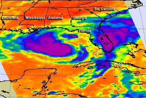
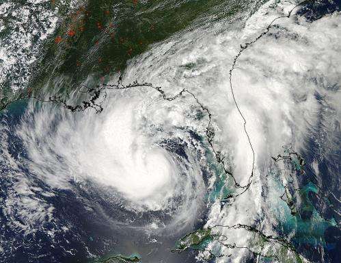
The Moderate Resolution Imaging Spectroradiometer (MODIS) instrument on NASA's Aqua satellite captured this visible image of Tropical Storm Isaac on Aug. 27 at 3:00 p.m. EDT is it was moving northwest through the Gulf of Mexico. Issac's large reach is seen by its eastern cloud cover over the entire state of Florida. At the same time, the Atmospheric Infrared Sounder (AIRS) instrument on Aqua captured infrared data on Isaac's clouds. Cloud top temperatures were colder than -63F (-52C) around the center of circulation and the western quadrant of the storm, and in a large band of thunderstorms east of the center of circulation, over Florida and parts of Cuba. That's where the strongest storms and heaviest rainfall was occurring.
On Aug. 28 at 8:40 a.m. EDT, a visible image of Tropical Storm Isaac taken from NOAA's GOES-13 satellite showed the huge extent of the storm, where the eastern-most clouds lie over the Carolinas and the western-most clouds are brushing east Texas. The image was created by the NASA GOES Project at the NASA Goddard Space Flight Center in Greenbelt, Md. Tropical-storm-force winds extend outward up to 205 miles (335 km) from the center of circulation, making the storm about 410 miles in diameter.

Warnings and watches in effect on Tuesday, Aug. 28, 2012 are many. A hurricane warning is in effect for east of Morgan City Louisiana to the Alabama-Florida Border, including Metropolitan New Orleans, Lake Pontchartrain, and Lake Maurepas. A hurricane watch is in effect for Intracoastal City to Morgan City, Louisiana. Tropical Storm Warnings are in effect from the Alabama-Florida border to the Aucilla River, and Morgan City to Cameron, Louisiana. A Tropical Storm Watch is in effect from east of High Island, Texas to just west of Cameron, Louisiana.
On Aug. 28 at 8 a.m. EDT, Tropical Storm Issac's maximum sustained winds were just under hurricane force, at 70 mph (110 kmh). The center of Tropical Storm Isaac was located near latitude 27.8 north and longitude 88.2 west, only about 105 miles (170 km) south-southeast of the mouth of the Mississippi River. Isaac is moving northwest at 7 mph (11 kmh) and is expected to continue in that direction for the next day or two, but it's speed is expected to fluctuate. The National Hurricane Center noted that the center of Isaac will be near or over the Louisiana coast tonight, Aug. 28, or early on Aug. 29.
Storm surge is a deadly part of any landfalling tropical cyclone. The National Hurricane Center (NHC) is warning that storm surge will be highest from Isaac from southeastern Louisiana to Mississippi, where surge levels are expected between 6 and 12 feet during times of high tide. Alabama's coast may experience surge between 4 and 8 feet, while south-central Louisiana and the Florida panhandle can expect between 3 and 6 feet. Florida's west coast including Apalachee Bay can expect a storm surge between 1 and 3 feet.
The NHC expects hurricane conditions in the northern Gulf Coast warning area during the afternoon of Aug. 28. As conditions worsen, isolated tornadoes are possible as with any landfalling tropical cyclone.
NASA's Tropical Rainfall Measuring Mission (TRMM) satellite has seen large rainfall rates within Tropical Storm Isaac, and those large rainfall rates and slow movement of the storm will lead to high rainfall totals. The National Hurricane Center expects 7 to 14 inches of rain with possible isolated maximum amounts of 20 inches in southeastern Louisiana, southern Mississippi, southern Alabama and the extreme western Florida Panhandle.
Provided by NASA's Goddard Space Flight Center


