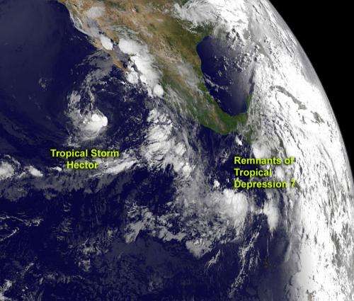
GOES-15 satellite sees fading Tropical Storm Hector and TD7's remnants

Two tropical cyclones were spotted from NOAA's GOES-15 satellite today, August 15.
Tropical Storm Hector continues to weaken in the Eastern Pacific Ocean, while the remnants of the Atlantic Ocean's Tropical Depression 7 are moving over Central America. NASA's GOES Project, located at NASA's Goddard Space Flight Center, Greenbelt, Md., uses the GOES-15 satellite data to create images and animations from the satellite. The NOAA GOES-15 satellite sits in a fixed orbit over the eastern U.S. and provides infrared and visible imagery of the Eastern Pacific Ocean basin continuously. In a visible image on August 15, 2012 at 8:00 a.m. EDT, the small circulation remaining from Tropical Storm Hector is spinning of the western coast of Mexico, while the remnants of Tropical Depression 7 were seen crossing over Central America.
Tropical Storm Hector
On August 15, 2012 at 5 a.m. EDT (0900 UTC), Tropical Storm Hector had maximum sustained winds near 40 mph (65 kmh). It was weakening as a result of atmospheric conditions and its movement into cooler waters. The National Hurricane Center noted "Hector will continue to be affected by 15-20 knots of east-southeasterly shear during the next couple of days," which are weakening the cyclone.
The center of Hector was located near latitude 17.2 north and longitude 115.2 west, about 525 miles (840 km) southwest of the southern tip of Baja California, Mexico. The National Hurricane Center noted that Hector has been lingering in the same area during the early morning hours of August 15, but is expected to move north-northwestward at about 5 mph (7 kmh) later today. Hector could become a tropical depression tonight or on Thursday, August 16.
Tropical Depression 7's Remnants
The remnants of Tropical Depression 7 (TD7) are now located over western Honduras and the coast of Belize. TD7 is still producing showers and thunderstorms, although they are disorganized. The showers and thunderstorms extend over the far northwestern Caribbean Sea to parts of Central America and Mexico's Yucatan Peninsula. That means locally heavy rains in those areas through Thursday, August 16 as TD7 moves to the west-northwest between 15 and 20 mph. The National Hurricane Center gives the TD7's remnants a "near zero percent" chance of becoming a tropical depression again in the next 48 hours as it continues to move across Central America. Once it gets into the Eastern Pacific Ocean, if it makes it there, may be a different story.
As Hector fades, forecasters will be keeping an eye on the remnants of Tropical Depression 7 to see what develops.
Provided by NASA's Goddard Space Flight Center


