NASA sees intensifying Hurricane Carlotta threatening Mexico

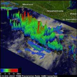
NASA's Tropical Rainfall Measuring Mission (TRMM) satellite flew over Carlotta when it was a tropical storm and found areas of heavy rain throughout and powerful high thunderstorms almost 10 miles high, hinting the storm would strengthen into a hurricane. By 8 a.m. EDT on June 15, Carlotta became the first hurricane of the eastern Pacific Ocean season.
As Carlotta neared the western coast of Mexico, warnings and watches were posted. On Friday, June 15, 2012, a hurricane warning was in effect for the Pacific Coast of Mexico from Salina Cruz to Acapulco. A hurricane watch is in effect for the Pacific Coast of Mexico east of Salina Cruz to Barra De Tonala, and west of Acapulco to Tecpan De Galeana.
A 3-D perspective image was created at NASA's Goddard Space Flight Center in Greenbelt, Md. by Hal Pierce of SSAI, who works on the TRMM mission team. Hal noted that the TRMM Precipitation Radar shows there were several powerful thunderstorms taller than 15km (~9.3 miles). The tallest convective thunderstorm towers, reaching above 16km (~9.9 miles), were seen on the northwestern side of the developing tropical cyclone. Those convective towers or "hot towers" usually indicate strengthening within 6 hours, and Carlotta did, indeed, become a hurricane.
TRMM imagery also showed that the storm was getting better organized with several areas of heavy rainfall located in forming convective rain bands.
At 11 a.m. EDT (8 a.m. PDT) Hurricane Carlotta's maximum sustained winds were near 80 mph making it officially the first hurricane of the Eastern Pacific Ocean hurricane season.
Carlotta was located about 120 miles (195 km) south-southeast of Puerto Angel and 330 miles (530 km) southeast of Acapulco, Mexico. Because tropical-storm-force winds extend out 50 miles (85 kilometer) from Carlotta's center, Puerto Angel was not yet experiencing them at 11 a.m. EDT (8 a.m. PDT), but that will change as Carlotta draws ever closer.
Carlotta's center was near latitude 14.0 north and longitude 96.0 west. Carlotta was moving to the northwest near 12 mph (19 kph) and is expected to continue in that direction over the next 24 hours before turning to the west-northwest and back to sea.
As Carlotta nears the coast, rainfall poses one of the biggest threats. Heavy rains resulting in flooding and landslides are then possible as Carlotta interacts with rugged terrain near the southwestern coast of Mexico. The National Hurricane Center has forecast accumulations of 3 to 5 inches (75 to 125 mm) with isolated maximum amounts of 12 inches (300 mm) over the Mexican states of Guerrero, Oaxaca and Chiapas. Storm surge and hurricane-force winds are also expected.
Provided by NASA's Goddard Space Flight Center


