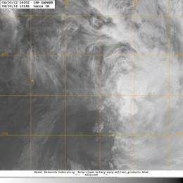
NASA infrared image sees a stronger Tropical Storm Daphne

Tropical Storm Daphne strengthened overnight and was captured in an infrared image from NASA's Terra satellite. Daphne moved away from the Fiji islands and remains north of New Zealand in the South Pacific on April 3, 2012.
NASA's Terra satellite passed over Daphne at 1014 UTC (6:14 a.m. EDT or 10:14 p.m. local time, Auckland, New Zealand), and used infrared imagery from the Moderate Imaging Spectroradiometer (MODIS) instrument to visualize its cloud extent. Like the infrared goggles used to see at night infrared satellite imagery can see cloud cover of tropical cyclones from space. The MODIS image showed Daphne to be more rounded and less elongated than it appeared in satellite imagery on April 2, indicating that wind shear had lessened. At that time, its minimum central pressure was 986 millibars.
On April 3 at 0300 UTC (April 2 at 11 a.m. EDT/3 p.m. local time, Auckland, New Zealand time), Tropical Storm Daphne had maximum sustained winds near 50 knots (57.5 mph/92.6 kph), up from 35 knots (40 mph/64 kph) on April 2. Daphne was located 744 nautical miles (856 miles/1378 km) east of Kingston Island, near 27.8 South and 178.0 West. Daphne was speeding to the southeast at 25 knots (28.7 mph/46.3 kph). As Daphne has moved, it has grown in size. Tropical-storm-force winds now extend as far as 300 nautical miles (345.2 miles/555.6 km) from the center, especially in the east and southern quadrants. Tropical-storm-force winds in the other quadrants appear to extend just further than 100 nautical miles (115 miles/185 km).
All warnings have been dropped for Fiji land areas, but mariners can expect rough seas between Fiji and New Zealand as Daphne continues moving southeast.
Forecasters at the Fleet Weather Center in Norfolk, Virginia are currently maintaining forecasts for tropical cyclones in the South Pacific. The current forecast takes Daphne on a south-southeasterly track over the next several days and keeps it away from New Zealand. Forecasters expect Daphne to begin weakening as it continues to move southeast as wind shear will increase and sea surface temperatures will drop.
Provided by NASA's Goddard Space Flight Center


