GOES satellite eyeing late season lows for tropical development

Its late in the Atlantic and eastern Pacific hurricane seasons, but the calendar isn't stopping the tropics. The GOES-13 satellite is keeping forecasters informed about developing lows like System 90E in the eastern Pacific and another low pressure area in the Atlantic.
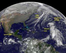
System 90E and the Atlantic low pressure area were both captured in one image from the NOAA's GOES-13 satellite today, November 18, 2011 at 1145 UTC (7:45 a.m. EST). The image was created by the NASA GOES Project (in partnership with NOAA) at NASA's Goddard Space Flight Center in Greenbelt, Maryland.
The low called System 90E appears to be getting organized on the GOES infrared imagery with the largest amount of clouds north and east of the low's center of circulation.
System 90E was located about 475 miles south of the Gulf of Tehuantepec near 9.2 North and 95.9 West at 1 a.m. EST on November 18. It was moving to the west at 15 mph, and is producing a concentrated area of showers and thunderstorms near its center of circulation, according to the National Hurricane Center (NHC). NHC gives System 90E a 40 percent chance of becoming a tropical depression over the weekend.
Meanwhile in the Atlantic Ocean GOES-13 captured another low pressure system that has less of a chance of developing this weekend. The low pressure area is located in the central Atlantic and appears elongated from north to south. It contains a large area of clouds and showers. The low is about 900 miles east and northeast of the Leeward Islands.
It developed from a combination of three factors: an interaction between a surface trough (elongated area) of low pressure, an upper level low pressure area and a tropical wave. The NHC expects slow development over the next couple of days, and has given it a 10 percent chance of development over the weekend.
West of the Atlantic Low is the strong cold front denoted by a line of clouds stretching from northeast to southwest that brought severe weather (including tornadoes) to the southeastern US on November 16.
Provided by NASA's Goddard Space Flight Center


