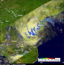
A eyes light rainfall in dissipating tropical depression Nalgae

Tropical Depression Nalgae weakened rapidly when it made landfall on Hainan Island, China yesterday and NASA's TRMM satellite observed lighter rainfall rates that coincided with its lower intensity. Today, Nalgae's remnants are moving drifting toward Vietnam.
TRMM measured the rainfall rates in Nalgae on October 4, 2011 at 0624 UTC (2:24 a.m. EDT). The rainfall analysis from TRMM's Microwave Imager (TMI) and Precipitation Radar (PR) showed only scattered areas of light to moderate rainfall were present with Nalgae as it moved into the Gulf of Tonkin west of Hainan Island. Rain was falling at a rate between .78 to 1.57 inches/20 to 40 mm per hour.
By October 5 at 1500 UTC (11 a.m. EDT), Nalgae had weakened into a remnant low pressure area with maximum sustained winds of 20 knots (23 mph/37 kmh) around its circulation center. It was located about 100 nautical miles north of Hue, Vietnam near 18.0 North and 107.3 East. The remnant low was drifting to the west-southwest at 2 knots (2 mph/4 kmh).
The forecasters at the Joint Typhoon Warning Center noted that the movement across Hainan Island weakened the system beyond the point of regeneration. There was no convection (rising air that forms thunderstorms that make up a tropical depression) evident today, Oct. 5. The remnant low is drifting to the coast today.
Provided by NASA's Goddard Space Flight Center


