NASA sees Hurricane Hilary's heaviest rain in northwest quadrant

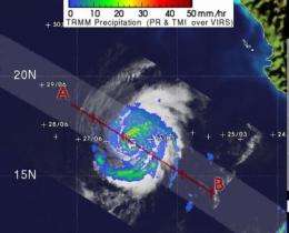
Hurricane Hilary pulled away from the western Mexico coastline this weekend, and NASA's TRMM satellite has monitored its rainfall. Hilary's heaviest rainfall is in its northwest quadrant, and falling over open ocean today, but Hilary may be headed back toward land.
NASA's Tropical Rainfall Measuring Mission satellite known as TRMM passed over Hilary on Sept. 26 at 5:29 a.m. EDT and its precipitation radar instrument measured rainfall happening throughout the storm from its orbit in space. TRMM saw that most of the rainfall occurring in Hurricane Hilary today was moderate, and the heaviest area was limited to its northwestern quadrant where rain was coming down at 2 inches/50 mm per hour.
TRMM also has the ability to measure cloud heights, which indicate the power within a hurricane. The higher the towering clouds around the eye, usually the stronger the power within the hurricane. TRMM noticed that the highest cumulonimbus (thunderstorm) clouds in the center were around 14 kilometers (8.6 miles). Towering clouds that height are indicative of a lot of power in the storm.
At 5 a.m. EDT (2 a.m. PDT) on Sept. 26, Hilary's maximum sustained winds were near 120 mph (195 kmh). It was centered near 16.9 North and 112.2 West, about 440 miles (710 km) south-southwest of the southern tip of Baja California. It is moving away from Mexico to the west at 10 mph (17 kmh) and has a minimum central pressure of 959 millibars.
Hilary is going through some changes today. It appears slightly elongated today from north to south. Cloud top temperatures in infrared satellite imagery indicate that her cloud tops are cooling, indicating they're going higher (and getting stronger).
The National Hurricane Center forecast calls for Hilary to change course and take a northeastern track, coming close to Baja California by the end of the week, but as a depression. Forecasters and NASA satellites are keeping a close eye on Hilary this week.
Provided by NASA's Goddard Space Flight Center


