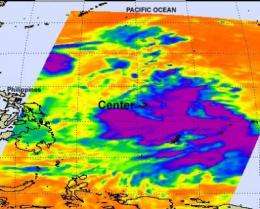
NASA identifies the areas of Tropical Storm Muifa's strength

The strongest thunderstorms that make up tropical storm Muifa are on the storm's eastern and southern sides, according to infrared imagery from NASA's Aqua satellite. The northern side is being weakened by a nearby weather system.
Tropical Storm Muifa is moving through the western North Pacific Ocean, and had strengthened during the early morning hours of July 28. On July 27, it was tropical depression 11W and winds have since increased to 40 knots (46 mph/74 kmh).
When NASA's Aqua satellite passed over Tropical Storm Muifa the Atmospheric Infrared Sounder (AIRS) instrument captured an infrared look at the storm's cold cloud tops and strong thunderstorms. The colder the cloud tops, the higher the thunderstorms and the stronger they are. The AIRS infrared image on July 27 at 1647 UTC (12:47 p.m. EDT) showed that the highest, coldest thunderstorms were on the eastern and southern sides of the center.
So why doesn't the northern side of Tropical Storm Muifa have any strong convection (rapidly rising air that form thunderstorms that make up the storm)? The answer is that Muifa is located 10 degrees southeast of a high pressure area in the western North Pacific Ocean that is preventing evaporation in the storm's northern quadrant. The high pressure area is pushing air downward toward the surface and preventing evaporation and formation of thunderstorms.
At 1200 UTC (8 a.m. EDT) on July 28, 2011, Muifa was located 655 nautical miles west of Andersen Air Force Base, Guam, near 12.4 North and 133.6 East. It was moving to the west-northwest near 12 knots (14 mph/22 kmh) and is expected to continue in that direction and turn more toward the north in the next couple of days.
Provided by NASA's Goddard Space Flight Center


