GOES-13 sees system 99L organizing tropically

The GOES-13 satellite keeps a continuous eye over the eastern U.S., the Caribbean Sea, Gulf of Mexico and Atlantic Ocean, and noticed that System 99L is much better organized today, October 20, hinting that it could become a tropical depression later today.
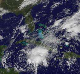
At 8 a.m. EDT on Wednesday, October 20, System 99L, a low pressure system about 150 miles southwest of Grand Cayman appears to be getting organized as it drifts eastward in the Caribbean Sea.
System 99L is showing more organization than it did yesterday, despite strong upper-level winds that are currently inhibiting significant development. Those winds, however, are expected to become more favorable for a tropical depression to form during the next day or so.
The Geostationary Operational Environmental Satellite called GOES-13 captured a visible image of System 99L today, Oct. 20 at 1431 UTC (10:31 a.m. EDT). GOES satellites are managed by NOAA. NASA's GOES Project at NASA's Goddard Space Flight Center in Greenbelt, Md. creates images and animations from the satellite data and created today's image that shows System 99L is getting organized and appears as a rounded area of clouds in the western Caribbean Sea.

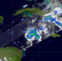
Earlier in the day, NASA and the Japanese Space Agency's Tropical Rainfall Measuring Mission (TRMM) satellite flew over System 99L and captured light to moderate rainfall throughout the storm. The TRMM team at NASA's Goddard Space Flight Center in Greenbelt, Md. creates rainfall imagery using data from various instruments aboard the satellite. Rain rates in the center of the TRMM swath were created from the TRMM Precipitation Radar (PR), the only spaceborne radar of its kind, while those in the outer portion are from the TRMM Microwave Imager (TMI). To put the image together, the rain rates were then overlaid on infrared data from the TRMM Visible Infrared Scanner.
The National Hurricane Center noted that a U.S. Air Force Reserve reconnaissance aircraft is scheduled to investigate this system later today. Even if System 99L doesn't become a tropical depression today, it is still going to bring heavy rainfall to the Cayman Islands and Jamaica during the next couple of days.
Provided by NASA's Goddard Space Flight Center


