Tropical Depression 6-E forms from System 96E, struggling in wind shear

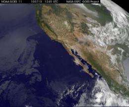
Yesterday, System 96E looked good for development and by 5 p.m. EDT that low pressure area had organized more to become Tropical Depression 6-E in the Eastern Pacific Ocean. Today, July 15, the GOES-11 satellite captured a visible image of the depression as it struggles to organize further against wind shear.
The Geostationary Operational Environmental Satellite called GOES-11 captured a visible image of Tropical Depression 6E (TD6E) more than 300 miles off the western Mexico coast, on July 15 at 1245 UTC (9:45 a.m. EDT).
By 5 a.m. EDT on July 15, TD6E was still poorly organized, as evidenced by the broken areas of clouds in the GOES-11 imagery. Moderate to strong vertical wind shear (winds that can tear a storm apart) are keeping the storm from developing more right now, and it is also causing the convection and showers to appear asymmetric. That moderate to strong wind shear is expected to wane about mid-day on Saturday, July 17, which may give Tropical Depression 6E a short window of time to strengthen for a brief time. As TD6E continues moving west-northwest over the weekend, it will move into cooler waters that will again sap the depression's strength.
TD6E had maximum sustained winds near 35 knots (38 mph) and was moving away from land in a west-northwestward direction at 9 mph. TD6E is expected to continue moving in the same general direction by forecasters at the National Hurricane Center (NHC), Miami, Fla.
TD6E was located about 370 miles southwest of Manzanillo, Mexico, or 540 miles south of the southern tip of Baja California near 15.2 North and 108.3 West. Minimum central pressure was near 1007 millibars.
Satellite data reveals numerous moderate and isolated strong convection (rapidly rising air that forms the thunderstorms that power the storm) within 200 nautical miles on the west side of the center.
The NHC said that some strengthening could occur over the next couple of days, so for a short time it could become Tropical Storm Estelle.
Provided by NASA's Goddard Space Flight Center


