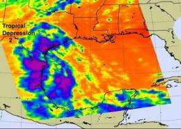
NASA satellites see high, cold thunderstorm cloud tops in Tropical Depression 2

NASA's Aqua and TRMM satellites confirmed that Tropical Depression Two (TD2) had some strong, high thunderstorms a day after its center made landfall. TD2 appears elongated on satellite imagery, and its rains stretch from southeastern Texas to northeastern Mexico. Those rains are still prompting flash flood watches and warnings.
NASA's Atmospheric Infrared Sounder (AIRS) instrument that flies aboard NASA's Aqua satellite captured an infrared look at TD2's high thunderstorm cloud tops on July 8 at 19:29 UTC (3:29 p.m. EDT) as its rains stretched from southeastern Texas to northeastern Mexico. The coldest cloud tops were as cold as -63F, and indicate areas of heavy rainfall.
Earlier in the day at 1020 UTC (6:20 a.m. EDT), the Tropical Rainfall Measuring Mission (TRMM) satellite flew over TD2 creating data used in a rainfall analysis. At that time, a small area of very heavy thunderstorms was located over the Gulf of Mexico east of the Texas-Mexico coast. TRMM's precipitation radar showed that some of the thunderstorms had tops extending upward to almost 15km (~9.3 miles), which indicate very strong storms, likely with heavy rainfall.
On Friday, July 9, at 5 a.m. EDT, the National Weather Service's Hydrometeorological Prediction Center (HPC) in Camp Springs, Md. noted that "Locally heavy rains continue to spread across the Rio Grande Valley."
As TD2's rainfall continues to sweep warm, moisture in from the Gulf of Mexico, flood and flash flood watches remain in effect across much of Texas. Coastal flood warnings remain in effect along portions of the western Gulf coast.
Some rain totals from the National Weather Service range from 2 inches to 5 inches in various locations. The largest rainfall total recorded was 5.16 inches at the Hads Guadalupe River in Victoria, Texas. Bloomington received 3.6 inches, Victoria Regional Airport received 2.86 inches, and Fort Hood received 2.47 inches.
The flood warning continues for the Guadalupe River near Bloomington affecting Calhoun and Victoria Counties in Texas, as recent heavy rainfall over the area will result in river rises above flood stage during the next few days.
At 5 a.m. EDT, TD2's center was about 115 miles southwest of Laredo, Texas near 26.5 North and 100.9 West. Maximum sustained winds were near 20 mph with higher gusts, and TD2 is expected to move farther inland into the higher terrain of northern Mexico later today or tonight, and dissipate over the weekend.
The HPC said that "Locally heavy showers will continue across Texas for the next couple of days. Additional rainfall amounts of 1 to 3 inches are possible...with isolated maximum totals of up to 8 inches for localized areas along the Texas/Mexico border."
Provided by NASA's Goddard Space Flight Center


