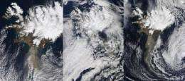
2 NASA Satellites Capture Last 3 Days of Eyjafjallajokull's Ash Plume

NASA's Aqua and Terra satellites fly around the world every day capturing images of weather, ice and land changes. Over the last three days these satellites have provided visible and infrared imagery of the ash plume from the Eyjafjallajökull volcano in Iceland.
Eyjafjallajökull is pronounced similar to "EYE-a-fyat-la-yu-goot," and it is still spewing ash into the atmosphere. Volcanic eruptions are important sources of gases, such as sulphur dioxide (SO2) and volcanic ash (aerosols) in the atmosphere.
The Moderate Resolution Imaging Spectroradiometer, also known as MODIS, is an instrument that flies aboard both NASA's Aqua and Terra satellites. MODIS captures daily visible and infrared earth imagery and has provided daily images of the volcanic plume. NASA's MODIS instrument and the Atmospheric Infrared Sounder (AIRS) instrument, both of which fly on Aqua, contain sulfur dioxide (SO2) absorption channels to enhance volcanic ash detection. These applications have significantly improved upon existing satellite-based multi-spectral techniques in identifying and tracking ash clouds and estimating their height.
On Saturday, April 17 at 13:20 UTC (9:20 a.m. EDT), Aqua captured a visible image of the ash plume so clearly that in the satellite image a viewer could see the billowing cloud spewing from the volcano and blowing almost due south before turning east over the Atlantic Ocean.
On Sunday, April 18 at 12:05 UTC (8:05 a.m. EDT), NASA's Terra satellite flew over the volcano and captured an image of the brown ash cloud mostly obscured by higher clouds. The brown plume was partly visible underneath the high clouds.
By Monday morning, April 19 at 12:50 UTC (8:50 a.m. EDT) the high clouds had cleared, and the brown line of spewed volcanic ash was visible once again blowing south, then turning east toward the United Kingdom.
The ash cloud basically consists of fine particles of pulverized rock. Volcanic ash is a rare but potentially catastrophic hazard to aviation. Encounters with volcanic ash while in flight can result in engine failure from particulate ingestion and viewing obstruction of the cockpit widescreen from etching by the acidic aerosols. Volcanic Ash Advisory Centers were established to monitor the air space in areas prone to eruptions and to issue volcanic ash warnings.
Provided by NASA's Goddard Space Flight Center


