Tropical Storm Olga: Three times a lady

Just like 1980s song by the Commodores, "Three Times a Lady," Olga has become a tropical storm for the third time in northern Australia. NASA satellite imagery showed that Olga's center moved back into the warm waters of the Gulf of Carpentaria and it has regained strength.
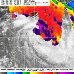
NASA's Aqua satellite saw Olga's center re-entering the Gulf early on January 29, and satellite imagery indicated the storm was strengthening.
Residents of the northern coastal areas in Australia's Northern Territory and Queensland are again under tropical cyclone warnings and watches, now that Olga is back in the Gulf. Olga isn't expected to stay in the Gulf more than a day, however, before it makes landfall near Normanton, Queensland on January 30.
A Cyclone Warning remains in effect for coastal and island communities from the Northern Territory/Queensland border to Kowanyama extending inland to Croydon in Queensland.
At 10 a.m. ET (1500 UTC) on Friday, January 29, Olga had maximum sustained winds near 39 mph, making her a tropical storm for the third time in her life. She was located 99 miles (160 km) east of Port McArthur and 87 miles (140 km) north of Burketown, near 16.1 degrees South latitude and 139.3 degrees East longitude. She's moving eastward at 17 mph (15 knots/28 km/hr).
Recent radar imagery from Mornington Island, Australia, revealed that Olga's low-level circulation center is again consolidating, indicating the storm is strengthening over the Gulf. Estimated sea level pressure is near 989 millibars. The wind shear in that area is weak, so that will further allow Olga to strengthen before she makes a third landfall in northern Queensland tomorrow.
NASA's Aqua satellite passed over Olga January 29 at 04:29 UTC (11:29 p.m. EST Jan. 28) and captured an image of the storm's winds with the Advanced Microwave Scanning Radiometer-E (AMSR-E) instrument. AMSR-E measured the winds on Olga's eastern side to be around 34 mph (30 knots/55 km/hr), just before she strengthened back to tropical storm status.
Data from AMSR-E provides measurements of precipitation rate, cloud water, water vapor, sea surface winds, and sea surface temperature, all of which are indicators in whether a tropical cyclone is strengthening or weakening. One unique aspect of AMSR-E sea surface temperature data is that it reads those surface temperatures through most types of cloud cover, supplementing infrared-based measurements that are restricted to cloud-free areas.
Olga is already generating 15-foot high waves in the southern Gulf of Carpentaria, so coastal residents should prepare for flooding conditions as well as gusty winds and heavy rainfall.
Provided by NASA's Goddard Space Flight Center


