Olga's track is a puzzle forecasters are putting together

One of the most complicated things about tropical cyclones is forecasting their tracks, and Olga is a prime example of that problem. The Joint Typhoon Warning Center believes that Olga will remain inland over Australia's Northern Territory, while the Australian Bureau of Meteorology has forecast Olga's reemergence into the Gulf of Carpentaria.
Satellite data, like that from NASA and JAXA's Tropical Rainfall Measuring Mission (TRMM), combined with ground weather station information, experience and several computer models help forecasters figure out where tropical cyclones may be headed.
On Thursday, January 28 at 09:00 UTC (4 a.m. ET) Olga was a tropical depression with maximum sustained winds near 34 mph (30 knots). Olga's center was still inland in the Northern Territory, and south of the coast of the Gulf of Carpentaria. Olga's center was about 34 miles west of Borroloola and 400 nautical miles southeast of Darwin, Australia, near 17.3 South latitude and 135.9 East longitude. Olga was moving south-southwest near 9 mph (8 knots), and the Joint Typhoon Warning Center expects her center to remain over land. However, the Australian Bureau of Meteorology is forecasting Olga to track north and back into the Gulf of Carpentaria.
Meanwhile, warnings remain in effect today. A Cyclone warning continues for coastal and island communities from Cape Shield to Burketown. In addition, a Cyclone Watch is up for coastal and island communities from Burketown to Pormpuraaw.
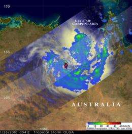
The TRMM satellite passed over tropical storm Olga when it was located over northern Australia near the coast of the Gulf of Carpentaria on January 27 at 0041 UTC. At that time, Olga was again a tropical storm, and TRMM revealed that it was dropping light to moderate rainfall along a large area of the Australia coast in the southern Gulf of Carpentaria.
TRMM's rainfall analysis is pretty complicated to create. It's assembled by research meteorologists at NASA's Goddard Space Flight Center in Greenbelt, Md. Rainfall analyses are derived from TRMM's Precipitation Radar (PR) and TRMM Microwave Imager instruments (TMI), and then overlaid on infrared and visible images from TRMM's Visible and Infrared Scanner (VIRS).
The Joint Typhoon Warning Center issued their final advisory on Olga today, although they will watch it for possible regeneration. The final bulletin noted that "Animated multispectral satellite imagery shows convective wrapping (showers and thunderstorms) into a developed low level circulation center and upper level analysis indicates the system is in a weak steering environment with low vertical wind shear." Weak steering means that nothing is available to push the storm in one way or another, which is why the Joint Typhoon Warning Center is expecting Olga to linger inland.
Further, animated visible satellite imagery has shown that Olga has kept tracking slowly southward over land.
The Australian Bureau of Meteorology noted in their Tropical Cyclone bulleting earlier today that "People between Burketown in Queensland and Cape Shield in the Northern Territory, including Groote Eylandt and Mornington Island, should take precautions." That's always good advice when a tropical cyclone is nearby.
Provided by NASA's Goddard Space Flight Center


